|
search place name
|
||
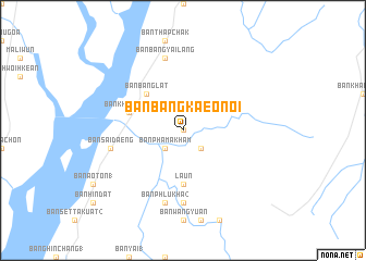
Ban Bang Kaeo Noi (Ranong, Thailand)Ban Bang Kaeo Noi is a town in the Ranong region of Thailand. An overview map of the region around Ban Bang Kaeo Noi is displayed below.
regional and 3d topo map of Ban Bang Kaeo Noi, Thailand ::
Ban Bang Kaeo Noi airports ::
The nearest airport is NST - Nakhon Si Thammarat Cha Ian, located 228.5 km south east of Ban Bang Kaeo Noi.
Nearby towns ::
Ban Bang Kaeo (0.0km north) //
Ban Hon (2.6km south east) //
Ban Phama Kham (2.6km south west) //
Ban Bang Lat (5.2km north west) //
Laun (5.6km south) //
Ban Bang Kaen Chan (5.6km south) //
Ban Khao Fachi (5.8km west) //
Ban Bang Kae (7.4km south) //
Ban Na Yao (7.4km south) //
Ban Bang Yai Lang (7.6km north) //
Ban Sai Daeng (7.5km west) //
Ban Phlu Kha (2) (7.6km south) //
[all distances 'as the bird flies' and approximate] 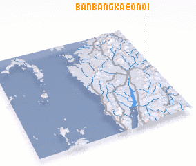 Places with similar names to Ban Bang Kaeo Noi, Thailand ::
// Ban Bang Kan (TH)
Disclaimer :: Information on this page comes without warranty of any kind |
||
|
Where is Ban Bang Kaeo Noi? Elevation and coordinates ::
Latitude (lat): 10°10'0"N Longitude (lon): 98°46'0"E
Elevation (approx.): 25m (map arrows pan, magnifying glasses zoom) |
||
|
Visiting Ban Bang Kaeo Noi? Hotel/Accommodation ::
Book a hotel in Ban Bang Kaeo Noi Travel Guide ::
Buy a travel guide for Thailand rental cars ::
car rental offers GPS waypoint ::
download a GPX waypoint (PoI) of Ban Bang Kaeo Noi for your GPS receiver
|
||