|
search place name
|
||
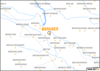
Ban Daen (Nakhon Sawan, Thailand)Ban Daen is a town in the Nakhon Sawan region of Thailand. An overview map of the region around Ban Daen is displayed below.
regional and 3d topo map of Ban Daen, Thailand ::
Ban Daen airports ::
The nearest airport is PHS - Phitsanulok, located 99.0 km north east of Ban Daen.
Other airports nearby include LOE - Loei (253.6 km north east), Nearby towns ::
Ban Huai Bai (1.8km west) //
Ban Ta Sang (2.6km south east) //
Ban Nam Ham (1) (2.7km south west) //
Ban Tha Chan (1) (4.0km south east) //
Ban Nam Hak (1) (4.0km south east) //
Ban Na Hup (4.1km south east) //
Ban Khlong Ngaeng (4.3km south east) //
Ban Pak Khlong (4.6km north west) //
Ban Bang Kaeo (5.1km north west) //
Ban Ton (6.2km south) //
Ban Krathum Thon (6.2km west) //
Ban Som Sieo (6.6km south east) //
Ban Wang (6.5km north west) //
Ban Mai Thai Bung (7.4km north) //
Ban Ko (8.2km north west) //
Ban Tha Kao (1) (8.0km south east) //
Ban Dong Kanghan (8.9km south) //
Ban Saen Saep Tai (9.1km south) //
Banphot Phisai (9.2km south east) //
[all distances 'as the bird flies' and approximate]  Places with similar names to Ban Daen, Thailand ::
Disclaimer :: Information on this page comes without warranty of any kind |
||
|
Where is Ban Daen? Elevation and coordinates ::
Latitude (lat): 15°58'0"N Longitude (lon): 99°54'0"E
Elevation (approx.): 44m (map arrows pan, magnifying glasses zoom) |
||
|
Visiting Ban Daen? Hotel/Accommodation ::
Book a hotel in Ban Daen Travel Guide ::
Buy a travel guide for Thailand rental cars ::
car rental offers GPS waypoint ::
download a GPX waypoint (PoI) of Ban Daen for your GPS receiver
|
||