|
search place name
|
||
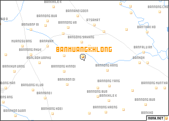
Ban Muang Khlong (Roi Et, Thailand)Ban Muang Khlong is a town in the Roi Et region of Thailand. An overview map of the region around Ban Muang Khlong is displayed below.
regional and 3d topo map of Ban Muang Khlong, Thailand ::
Ban Muang Khlong airports ::
The nearest airport is ZVK - Savannakhet, located 130.0 km north east of Ban Muang Khlong.
Other airports nearby include SNO - Sakon Nakhon (158.5 km north), UTH - Udon Thani (209.5 km north west), NAK - Nakhon Ratchasima Khorat (211.4 km south west), PKZ - Pakse (220.6 km east), Nearby towns ::
Ban Waeng (3.3km north) //
Ban Dong Sawang (4.1km north) //
Ban Khoi (4.5km west) //
Ban Nong Hin Noi (4.9km south west) //
Ban Nong Hang (5.3km south east) //
Ban Kao Noi (6.5km south west) //
Ban Nam Kham (6.7km south east) //
Ban Hora (7.5km north west) //
Ban Chu Chat (7.7km north east) //
Ban Nong Yang (7.8km south east) //
Ban Nong Wa (8.1km north west) //
At Samat (8.2km north) //
Ban Nong Bua (8.5km south) //
Ban Pham (8.5km west) //
Ban Khilek (10.3km south east) //
Ban Nong Rua (11.4km north west) //
Ban Nong Bua (11.7km north west) //
Ban Na Noi (11.8km south west) //
[all distances 'as the bird flies' and approximate]  Places with similar names to Ban Muang Khlong, Thailand ::
// Ban Moeng Khloeng (TH)
// Ban Mong Klang (TH)
// Ban Muang Klang (TH)
// Ban Muang Klang (TH)
// Ban Mueang Klang (TH)
Disclaimer :: Information on this page comes without warranty of any kind |
||
|
Where is Ban Muang Khlong? Elevation and coordinates ::
Latitude (lat): 15°47'18"N Longitude (lon): 103°50'25"E
Elevation (approx.): 144m (map arrows pan, magnifying glasses zoom) |
||
|
Visiting Ban Muang Khlong? Hotel/Accommodation ::
Book a hotel in Ban Muang Khlong Travel Guide ::
Buy a travel guide for Thailand rental cars ::
car rental offers GPS waypoint ::
download a GPX waypoint (PoI) of Ban Muang Khlong for your GPS receiver
|
||