|
search place name
|
||
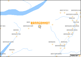
Ban Ngom Mot (Uttaradit, Thailand)Ban Ngom Mot is a town in the Uttaradit region of Thailand. An overview map of the region around Ban Ngom Mot is displayed below.
regional and 3d topo map of Ban Ngom Mot, Thailand ::
Ban Ngom Mot airports ::
The nearest airport is PRH - Phrae, located 62.9 km west of Ban Ngom Mot.
Other airports nearby include LOE - Loei (120.0 km south east), LPT - Lampang (134.4 km west), PHS - Phitsanulok (139.6 km south), VTE - Vientiane Wattay Intl (193.8 km east), Nearby towns ::
Ban Ngom Tham (4.0km north west) //
Ban Ngom Sak (5.3km west) //
Ban Huai Chaeo (5.6km east) //
Amphoe Fak Tha (9.1km south east) //
Ban Bung (9.1km south east) //
[all distances 'as the bird flies' and approximate] 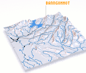 Places with similar names to Ban Ngom Mot, Thailand ::
// Ben Guemoud (MA)
// Ban Kam Maet (TH)
// Ban Kam Maet (TH)
// Ban Na Kaum Tai (TH)
// Bangamote (CD)
// Bonkamadou (GN)
// Ban Kèomat (LA)
// Buôn Ea Kmăt (VN)
// Buôn Ea Kmŭt (VN)
// Bungmati (NP)
Disclaimer :: Information on this page comes without warranty of any kind |
||
|
Where is Ban Ngom Mot? Elevation and coordinates ::
Latitude (lat): 17°58'0"N Longitude (lon): 100°44'0"E
Elevation (approx.): 836m (map arrows pan, magnifying glasses zoom) |
||
|
Visiting Ban Ngom Mot? Hotel/Accommodation ::
Book a hotel in Ban Ngom Mot Travel Guide ::
Buy a travel guide for Thailand rental cars ::
car rental offers GPS waypoint ::
download a GPX waypoint (PoI) of Ban Ngom Mot for your GPS receiver
|
||