|
search place name
|
||
Ban Pak Huai Dan (Phetchabun, Thailand)Ban Pak Huai Dan is a town in the Phetchabun region of Thailand. An overview map of the region around Ban Pak Huai Dan is displayed below.
regional and 3d topo map of Ban Pak Huai Dan, Thailand ::

Ban Pak Huai Dan airports ::
The nearest airport is PHS - Phitsanulok, located 100.3 km west of Ban Pak Huai Dan.
Other airports nearby include LOE - Loei (108.2 km north east), UTH - Udon Thani (190.2 km north east), PRH - Phrae (202.1 km north west), NAK - Nakhon Ratchasima Khorat (207.0 km south east), Nearby towns ::
Ban Omkong (2.6km south west) //
Ban Pho Thong (2.6km south east) //
Ban Bung Khla (5.1km north west) //
Ban Nong Khan (5.6km east) //
Ban Nam Kham Klang (5.6km east) //
Ban Bung Khla (5.6km west) //
Ban Tha Kham (5.6km west) //
Ban Nam Duk Klang (5.6km east) //
Ban Wang Song (5.8km south) //
Ban Tha Phon (6.5km south west) //
Ban Khlong Si Fan (6.6km north west) //
Ban Dong (6.6km south west) //
Ban Nam Len (7.3km east) //
Ban Huai Sawing (7.3km east) //
Ban Pho Ngam (7.3km west) //
Ban Khlong Bong (10.3km north east) //
Ban Mu But (10.3km north west) //
[all distances 'as the bird flies' and approximate] 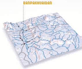 Places with similar names to Ban Pak Huai Dan, Thailand :: Disclaimer :: Information on this page comes without warranty of any kind |
||
|
Where is Ban Pak Huai Dan? Elevation and coordinates ::
Latitude (lat): 16°36'0"N Longitude (lon): 101°12'0"E
Elevation (approx.): 134m (map arrows pan, magnifying glasses zoom) |
||
|
Visiting Ban Pak Huai Dan? Hotel/Accommodation ::
Book a hotel in Ban Pak Huai Dan Travel Guide ::
Buy a travel guide for Thailand rental cars ::
car rental offers GPS waypoint ::
download a GPX waypoint (PoI) of Ban Pak Huai Dan for your GPS receiver
|
||