|
search place name
|
||
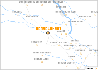
Ban Salok Bat (Kamphaeng Phet, Thailand)Ban Salok Bat is a town in the Kamphaeng Phet region of Thailand. An overview map of the region around Ban Salok Bat is displayed below.
regional and 3d topo map of Ban Salok Bat, Thailand ::
Ban Salok Bat airports ::
The nearest airport is PHS - Phitsanulok, located 100.6 km north east of Ban Salok Bat.
Other airports nearby include LOE - Loei (259.2 km north east), Nearby towns ::
Ban Wang (4.5km east) //
Ban Krathum Thon (5.4km south east) //
Ban Bo Tham (5.8km south west) //
Ban Pak Khlong (6.2km east) //
Ban Bang Kaeo (6.3km east) //
Ban Ko (7.5km north east) //
Ban Khlong Kradan (8.3km south) //
Ban Dong Dam (8.6km north west) //
Ban Huai Bai (8.7km east) //
Ban Nam Ham (1) (9.3km south east) //
Khanu Woralaksaburi (10.0km north east) //
Ban Khok Lo (11.2km north west) //
[all distances 'as the bird flies' and approximate] 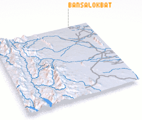 Places with similar names to Ban Salok Bat, Thailand :: Disclaimer :: Information on this page comes without warranty of any kind |
||
|
Where is Ban Salok Bat? Elevation and coordinates ::
Latitude (lat): 15°59'47"N Longitude (lon): 99°48'28"E
Elevation (approx.): 50m (map arrows pan, magnifying glasses zoom) |
||
|
Visiting Ban Salok Bat? Hotel/Accommodation ::
Book a hotel in Ban Salok Bat Travel Guide ::
Buy a travel guide for Thailand rental cars ::
car rental offers GPS waypoint ::
download a GPX waypoint (PoI) of Ban Salok Bat for your GPS receiver
|
||