|
search place name
|
||
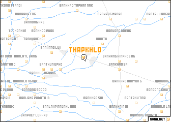
Thap Khlo (Phichit, Thailand)Thap Khlo is a town in the Phichit region of Thailand. An overview map of the region around Thap Khlo is displayed below.
regional and 3d topo map of Thap Khlo, Thailand ::
Thap Khlo airports ::
The nearest airport is PHS - Phitsanulok, located 74.8 km north west of Thap Khlo.
Other airports nearby include LOE - Loei (187.1 km north east), NAK - Nakhon Ratchasima Khorat (211.9 km south east), PRH - Phrae (221.7 km north), VTE - Vientiane Wattay Intl (292.9 km north east), Nearby towns ::
Ban I Tu (5.1km north east) //
Ban Thai Thung (5.7km west) //
Ban Wang Hin Phoeng (7.1km east) //
Ban Khao Sai (7.4km east) //
Ban Wang Lum (7.4km west) //
Ban Thung Pho (7.4km west) //
Ban Wang Daeng (9.0km north east) //
[all distances 'as the bird flies' and approximate] 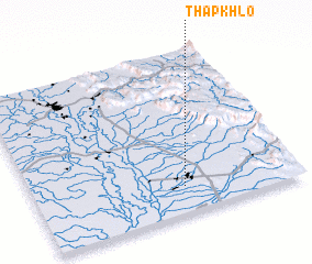 Places with similar names to Thap Khlo, Thailand :: Disclaimer :: Information on this page comes without warranty of any kind |
||
|
Where is Thap Khlo? Elevation and coordinates ::
Latitude (lat): 16°10'0"N Longitude (lon): 100°34'0"E
Elevation (approx.): 42m (map arrows pan, magnifying glasses zoom) |
||
|
Visiting Thap Khlo? Hotel/Accommodation ::
Book a hotel in Thap Khlo Travel Guide ::
Buy a travel guide for Thailand rental cars ::
car rental offers GPS waypoint ::
download a GPX waypoint (PoI) of Thap Khlo for your GPS receiver
|
||