|
search place name
|
||
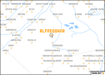
Alfredówka (Poland)Alfredówka is a town in Poland. An overview map of the region around Alfredówka is displayed below.
regional and 3d topo map of Alfredówka, Poland ::
Alfredówka airports ::
The nearest airport is RZE - Rzeszow Jasionka, located 44.1 km south east of Alfredówka.
Other airports nearby include KRK - Krakow Balice (146.6 km west), TAT - Poprad Tatry (189.3 km south west), WAW - Warsaw Okecie (196.7 km north), KSC - Kosice (203.9 km south), Nearby towns ::
Tarnowska Wola (1.9km south) //
Nowa Dęba (3.9km south) //
Poręby Dębskie (5.6km south) //
Grądki (6.0km north west) //
Poręby Majdańskie (7.4km south) //
Siedlisko (7.5km north) //
Jadachy (5.1km west) //
Janówka (5.1km west) //
Rozalin (5.1km west) //
Cygany (6.6km north west) //
Huta Komorowska (7.8km south) //
Przezgacz (7.3km south east) //
Drozdów (8.2km south east) //
Chmielów (7.3km north west) //
[all distances 'as the bird flies' and approximate]  Places with similar names to Alfredówka, Poland ::
// Al Ghardaqah (EG)
// Alfourtouk (NE)
Disclaimer :: Information on this page comes without warranty of any kind |
||
|
Where is Alfredówka? Elevation and coordinates ::
Latitude (lat): 50°28'0"N Longitude (lon): 21°45'0"E
Elevation (approx.): 152m (map arrows pan, magnifying glasses zoom) |
||
|
Visiting Alfredówka? Hotel/Accommodation ::
Book a hotel in Alfredówka Travel Guide ::
Buy a travel guide for Poland rental cars ::
car rental offers GPS waypoint ::
download a GPX waypoint (PoI) of Alfredówka for your GPS receiver
|
||