|
search place name
|
||
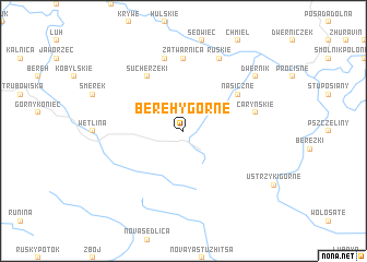
Berehy Górne (Poland)Berehy Górne is a town in Poland. An overview map of the region around Berehy Górne is displayed below.
regional and 3d topo map of Berehy Górne, Poland ::
Berehy Górne airports ::
The nearest airport is KSC - Kosice, located 111.2 km south west of Berehy Górne.
Other airports nearby include RZE - Rzeszow Jasionka (113.9 km north), LWO - Lvov Lviv Intl (124.8 km north east), SUJ - Satu Mare (162.6 km south), BAY - Baia Mare Tautii Magheraus (178.8 km south), Nearby towns ::
Nasiczne (5.2km north east) //
Suche Rzeki (6.1km north west) //
Zatwarnica (7.4km north) //
Caryńskie (5.2km east) //
Kalinów (7.5km north) //
Ruskie (7.8km north) //
Dwernik (7.4km north east) //
[all distances 'as the bird flies' and approximate]  Places with similar names to Berehy Górne, Poland ::
// Baiergrün (DE)
// Bergarn (DE)
// Burgrain (DE)
// Burgrain (DE)
// Barcarena (PT)
// Birch Run (US)
// Bāraikaran (BD)
// Barquereña (CO)
// Baragrān (IN)
// Bar Kārīn (PK)
Disclaimer :: Information on this page comes without warranty of any kind |
||
|
Where is Berehy Górne? Elevation and coordinates ::
Latitude (lat): 49°9'0"N Longitude (lon): 22°34'0"E
Elevation (approx.): 921m (map arrows pan, magnifying glasses zoom) |
||
|
Visiting Berehy Górne? Hotel/Accommodation ::
Book a hotel in Berehy Górne Travel Guide ::
Buy a travel guide for Poland rental cars ::
car rental offers GPS waypoint ::
download a GPX waypoint (PoI) of Berehy Górne for your GPS receiver
|
||