|
search place name
|
||
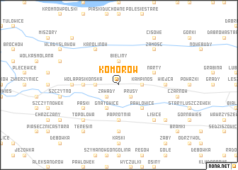
Komorów (Poland)Komorów is a town in Poland. An overview map of the region around Komorów is displayed below.
regional and 3d topo map of Komorów, Poland ::
Komorów airports ::
The nearest airport is WAW - Warsaw Okecie, located 38.2 km east of Komorów.
Other airports nearby include KTW - Katowice Pyrzowice (220.6 km south west), Nearby towns ::
Grabnik (2.2km north west) //
Granica (2.2km north east) //
Zawady (2.2km south west) //
Prusy (2.2km south east) //
Bieliny (3.7km north) //
Łazy (2.3km west) //
Kampinos (2.3km east) //
Gnatowice (3.9km south) //
Pawłowice (4.3km south east) //
Wola Pasikońska (3.4km west) //
Paprotnia (5.6km south) //
Narty (3.9km north east) //
Karolinów (6.0km north) //
Paski (5.0km south west) //
Strzyżew (4.5km west) //
Wiejca (4.5km east) //
Niepokalanów Klasztorny (7.4km south) //
Zamość (6.5km north east) //
Topolowa (6.5km south west) //
Lisice (6.5km south east) //
Cisowe (8.2km north east) //
Teresin (8.2km south west) //
Gaj (8.2km south west) //
Cholewy (7.2km south east) //
Famułki Królewskie (8.7km north west) //
[all distances 'as the bird flies' and approximate] 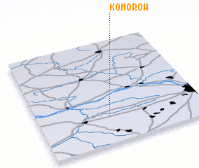 Places with similar names to Komorów, Poland ::
Disclaimer :: Information on this page comes without warranty of any kind |
||
|
Where is Komorów? Elevation and coordinates ::
Latitude (lat): 52°16'0"N Longitude (lon): 20°26'0"E
Elevation (approx.): 80m (map arrows pan, magnifying glasses zoom) |
||
|
Visiting Komorów? Hotel/Accommodation ::
Book a hotel in Komorów Travel Guide ::
Buy a travel guide for Poland rental cars ::
car rental offers GPS waypoint ::
download a GPX waypoint (PoI) of Komorów for your GPS receiver
|
||