|
search place name
|
||
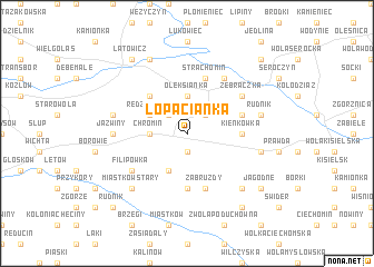
Łopacianka (Poland)Łopacianka is a town in Poland. An overview map of the region around Łopacianka is displayed below.
regional and 3d topo map of Łopacianka, Poland ::
Łopacianka airports ::
The nearest airport is WAW - Warsaw Okecie, located 64.5 km west of Łopacianka.
Other airports nearby include RZE - Rzeszow Jasionka (206.9 km south), Nearby towns ::
Gościewicz (1.9km south) //
Iwowe (2.2km north east) //
Laliny (2.2km north west) //
Chromin (2.3km west) //
Chrominek (2.3km west) //
Oleksianka (3.7km north) //
Redzyńskie (2.9km north west) //
Brzuskowola (3.9km south) //
Kolonia Redzyńskie (4.4km north west) //
Kujawy (5.6km south) //
Kienkówka (3.4km east) //
Kochany (3.9km north east) //
Wola Miastkowska (5.7km south) //
Zabruzdy (5.7km south) //
Strachomin (5.7km north) //
Zebraczka (5.0km north east) //
Borki (6.0km north) //
Filipówka (5.0km south west) //
Brzuza Stara (5.0km south west) //
Jaźwiny (4.6km west) //
Rudnik (4.9km east) //
Jamielne (4.9km east) //
Budziska (4.9km west) //
Kolonia Prawda Nowa (4.9km east) //
Kruszówka (6.5km south east) //
Miastków Stary (6.5km south west) //
Dąbrówka (7.8km north) //
Latowicz (8.2km north west) //
Jagodne (7.2km south east) //
[all distances 'as the bird flies' and approximate]  Places with similar names to Łopacianka, Poland ::
// Lopushanka (UA)
// Lapchenki (RU)
// Lapshanga (RU)
// Lapshanka (RU)
// Lapshinka (RU)
// Lapushinka (RU)
// Lipchanka (RU)
// Lipchenko (RU)
// Lopshen'ga (RU)
// La Pichinga (DO)
Disclaimer :: Information on this page comes without warranty of any kind |
||
|
Where is Łopacianka? Elevation and coordinates ::
Latitude (lat): 51°58'0"N Longitude (lon): 21°51'0"E
Elevation (approx.): 172m (map arrows pan, magnifying glasses zoom) |
||
|
Visiting Łopacianka? Hotel/Accommodation ::
Book a hotel in Łopacianka Travel Guide ::
Buy a travel guide for Poland rental cars ::
car rental offers GPS waypoint ::
download a GPX waypoint (PoI) of Łopacianka for your GPS receiver
|
||