|
search place name
|
||
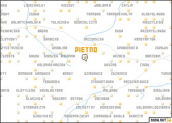
Piętno (Poland)Piętno is a town in Poland. An overview map of the region around Piętno is displayed below.
regional and 3d topo map of Piętno, Poland ::
Piętno airports ::
The nearest airport is POZ - Poznan Lawica, located 113.4 km north west of Piętno.
Other airports nearby include WRO - Wroclaw Strachowice (143.7 km south west), KTW - Katowice Pyrzowice (179.0 km south), KRK - Krakow Balice (238.0 km south east), Nearby towns ::
Wielopole (1.9km north) //
Bibianna (2.3km west) //
Imiełków (2.9km north east) //
Grzymiszew (3.9km north) //
Dziadowice (3.9km south) //
Brody (4.4km south west) //
Borowiec (3.4km east) //
Wróblina (3.9km north west) //
Deszno (3.9km south east) //
Kotwasice (5.7km south) //
Zygmuntówek (6.0km south) //
Ogorzelczyn (7.4km north) //
Albertów (4.6km east) //
Wrząca (4.6km east) //
Smaszew (4.6km west) //
Feliksów (7.5km south) //
Kolonia Smaszew (4.9km west) //
Kolonia Franulew (6.5km south east) //
Sarbicko (5.9km north west) //
Zdzienice (5.9km south east) //
Tuliszków (8.2km north west) //
Ruda (7.2km north east) //
Malanów (8.2km south east) //
Teodorów (7.2km south west) //
Kazała Stara (8.7km south west) //
[all distances 'as the bird flies' and approximate]  Places with similar names to Piętno, Poland ::
Disclaimer :: Information on this page comes without warranty of any kind |
||
|
Where is Piętno? Elevation and coordinates ::
Latitude (lat): 52°1'0"N Longitude (lon): 18°21'0"E
Elevation (approx.): 132m (map arrows pan, magnifying glasses zoom) |
||
|
Visiting Piętno? Hotel/Accommodation ::
Book a hotel in Piętno Travel Guide ::
Buy a travel guide for Poland rental cars ::
car rental offers GPS waypoint ::
download a GPX waypoint (PoI) of Piętno for your GPS receiver
|
||