|
search place name
|
||
Los Sitios (Camagüey, Cuba)Los Sitios is a town in the Camagüey region of Cuba. An overview map of the region around Los Sitios is displayed below.
regional and 3d topo map of Los Sitios, Cuba ::

Los Sitios airports ::
The nearest airport is CMW - Camaguey Ignacio Agramonte Intl, located 57.3 km east of Los Sitios.
Other airports nearby include AVI - Ciego De Avila Maximo Gomez (80.3 km north west), VTU - Las Tunas Hermanos Ameijeiras (158.7 km east), MZO - Manzanillo Sierra Maestra (183.7 km south east), SNU - Santa Clara Abel Santamaria (200.1 km north west), Nearby towns ::
Rodofo Ramírez Equivel (2.3km south) //
Viamones (5.6km south) //
Santa Gertrudis (5.6km north) //
Miranda (6.1km north west) //
Casa Vieja (6.2km south east) //
Hato Arriba (6.3km east) //
El Trece (6.9km south) //
El Seis (7.0km south east) //
La Portuerza (7.1km north east) //
Jesús María (7.6km south east) //
La Carbonera (8.0km south) //
San Nicolás (8.2km north) //
La Habana (7.9km south east) //
San Juan Bosco (10.3km north east) //
[all distances 'as the bird flies' and approximate] 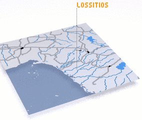 Places with similar names to Los Sitios, Cuba ::
// Los Sitios (PA)
// Los Sitios (PA)
// Los Sitios (CU)
// Los Sitios (ES)
// Los Sitios (CO)
// Los Sitios (GT)
// Los Tíos (MX)
// Los Atios (HN)
// Los Sitios (VE)
// Los Sitios (VE)
Disclaimer :: Information on this page comes without warranty of any kind |
||
|
Where is Los Sitios? Elevation and coordinates ::
Latitude (lat): 21°24'0"N Longitude (lon): 78°24'0"W
Elevation (approx.): 18m (map arrows pan, magnifying glasses zoom) |
||
|
Visiting Los Sitios? Hotel/Accommodation ::
Book a hotel in Los Sitios Travel Guide ::
Buy a travel guide for Cuba rental cars ::
car rental offers GPS waypoint ::
download a GPX waypoint (PoI) of Los Sitios for your GPS receiver
|
||