|
search place name
|
||
Cerkovinë (Vlorë, Albania)Cerkovinë is a town in the Vlorë region of Albania. An overview map of the region around Cerkovinë is displayed below.
regional and 3d topo map of Cerkovinë, Albania ::

Cerkovinë airports ::
The nearest airport is TIA - Tirana Rinas, located 96.4 km north of Cerkovinë.
Other airports nearby include CFU - Kerkyra/corfu Ioannis Kapodistrias Intl (113.1 km south), LCC - Lecce (120.3 km west), OHD - Ohrid (126.1 km north east), BDS - Brindisi Casale (130.5 km west), Nearby towns ::
Skrofotinë (0.8km west) //
Hoshtimë (2.8km south) //
Trevëllazër (2.7km north east) //
Panaja (3.4km south) //
Kërkovë (4.2km south) //
Mifol (4.6km north) //
Drithas (4.2km south east) //
Aliban (4.9km north) //
Bestrovë (5.3km south) //
Mekat (4.2km south east) //
Llakatund (4.7km south east) //
Beshisht (4.3km east) //
(( Mëkat i Ri )) (4.5km south east) //
(( Goricë )) (5.7km south) //
Bestrova e Vogël (5.9km south) //
Bunavi (5.5km south east) //
Grabian (5.6km south east) //
(( Trocaj )) (6.3km north east) //
Novoselë (6.7km north) //
Adë (6.4km north east) //
Kashisht (6.0km north east) //
Sheq (6.6km north east) //
(( Kallm Resulaj )) (6.0km north east) //
Babica e Vogël (7.5km south) //
Çeprat (7.2km south east) //
Fitore (7.5km north) //
Murtez (7.3km north east) //
Nartë (7.8km south) //
Çerven (8.3km north) //
[all distances 'as the bird flies' and approximate] 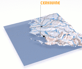 Places with similar names to Cerkovinë, Albania ::
// Čerakovina (BA)
// Žarkovina (BA)
// Sar Keyvān (IR)
// Sorkhvān (IR)
// Cerkovna (SI)
// Cirkvena (HR)
// Zarkovina (CS)
Disclaimer :: Information on this page comes without warranty of any kind |
||
|
Where is Cerkovinë? Elevation and coordinates ::
Latitude (lat): 40°33'57"N Longitude (lon): 19°29'3"E
Elevation (approx.): 43m (map arrows pan, magnifying glasses zoom) |
||
|
Visiting Cerkovinë? Hotel/Accommodation ::
Book a hotel in Cerkovinë Travel Guide ::
Buy a travel guide for Albania rental cars ::
car rental offers GPS waypoint ::
download a GPX waypoint (PoI) of Cerkovinë for your GPS receiver
|
||