|
search place name
|
||
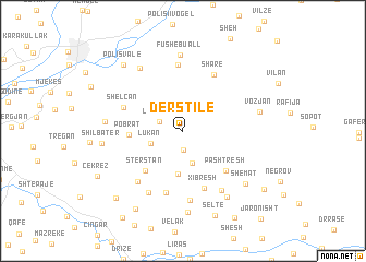
Dërstilë (Elbasan, Albania)Dërstilë is a town in the Elbasan region of Albania. An overview map of the region around Dërstilë is displayed below.
regional and 3d topo map of Dërstilë, Albania ::
Dërstilë airports ::
The nearest airport is OHD - Ohrid, located 49.1 km east of Dërstilë.
Other airports nearby include TIA - Tirana Rinas (57.2 km north west), KSO - Kastoria Aristotelis (113.5 km south east), SKP - Skopje (157.5 km north east), IOA - Ioannina (158.6 km south), Nearby towns ::
Gjinar (1.9km south) //
Lleshan (2.0km north west) //
Maskarth (3.4km south) //
Lukan (2.8km south west) //
Valësh (4.4km south) //
Pobrat (4.2km west) //
Stërstan (5.0km south west) //
Pashtresh (5.3km south east) //
Xibresh (6.0km south) //
Sharë (6.2km north east) //
Shelcan (5.2km north west) //
Shumeplaku (6.5km south) //
(( Vasjan )) (6.7km north) //
Zall (6.2km south west) //
Kaferr (7.2km south) //
Panç (6.9km south west) //
Manth (6.8km south east) //
Fushë-Buall (7.8km north) //
Shushicë (7.2km north west) //
Trepsenisht (6.1km west) //
Vozjan (6.3km east) //
Nezhan (7.6km south east) //
Paraspun (8.3km south) //
Shemat (7.3km south east) //
Shilbatër (6.4km west) //
(( Polis Valë )) (8.1km north west) //
Seltë (9.0km south) //
Bizhdan (8.8km south west) //
Katund Plak (8.6km south west) //
[all distances 'as the bird flies' and approximate]  Places with similar names to Dërstilë, Albania ::
Disclaimer :: Information on this page comes without warranty of any kind |
||
|
Where is Dërstilë? Elevation and coordinates ::
Latitude (lat): 41°2'23"N Longitude (lon): 20°11'17"E
Elevation (approx.): 814m (map arrows pan, magnifying glasses zoom) |
||
|
Visiting Dërstilë? Hotel/Accommodation ::
Book a hotel in Dërstilë Travel Guide ::
Buy a travel guide for Albania rental cars ::
car rental offers GPS waypoint ::
download a GPX waypoint (PoI) of Dërstilë for your GPS receiver
|
||