|
search place name
|
||
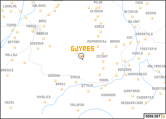
Gjyrës (Korçë, Albania)Gjyrës is a town in the Korçë region of Albania. An overview map of the region around Gjyrës is displayed below.
regional and 3d topo map of Gjyrës, Albania ::
Gjyrës airports ::
The nearest airport is KSO - Kastoria Aristotelis, located 36.1 km east of Gjyrës.
Other airports nearby include OHD - Ohrid (69.8 km north), KZI - Kozani Filippos (86.8 km east), IOA - Ioannina (96.1 km south), CFU - Kerkyra/corfu Ioannis Kapodistrias Intl (135.0 km south west), Nearby towns ::
Bradvicë (1.9km north west) //
Grapsh (2.6km north) //
Përparimaj (3.8km north east) //
Ziçisht (3.4km east) //
Çipan (3.6km east) //
Sul (4.0km south east) //
Koshnicë (4.4km south east) //
Sinicë (5.2km south) //
Hoçisht (5.9km north east) //
Qytezë (7.1km south) //
Gracë (7.0km north east) //
Miras (6.9km south east) //
Çetë (7.2km south east) //
Fitore (5.8km east) //
Dardhë (6.7km south west) //
Borsh (6.3km north east) //
Moravë (6.5km north west) //
Arrëz (7.6km south west) //
Menkulas (6.8km south east) //
Baban (8.7km north) //
Barç (10.1km north west) //
[all distances 'as the bird flies' and approximate] 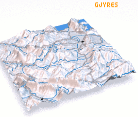 Places with similar names to Gjyrës, Albania ::
Disclaimer :: Information on this page comes without warranty of any kind |
||
|
Where is Gjyrës? Elevation and coordinates ::
Latitude (lat): 40°33'39"N Longitude (lon): 20°53'2"E
Elevation (approx.): 1109m (map arrows pan, magnifying glasses zoom) |
||
|
Visiting Gjyrës? Hotel/Accommodation ::
Book a hotel in Gjyrës Travel Guide ::
Buy a travel guide for Albania rental cars ::
car rental offers GPS waypoint ::
download a GPX waypoint (PoI) of Gjyrës for your GPS receiver
|
||