|
search place name
|
||
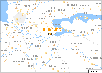
Vau i Dejës (Shkodër, Albania)Vau i Dejës is a town in the Shkodër region of Albania. An overview map of the region around Vau i Dejës is displayed below.
regional and 3d topo map of Vau i Dejës, Albania ::
Vau i Dejës airports ::
The nearest airport is TGD - Podgorica, located 49.5 km north west of Vau i Dejës.
Other airports nearby include TIA - Tirana Rinas (66.6 km south), TIV - Tivat (86.4 km north west), DBV - Dubrovnik (127.5 km north west), OHD - Ohrid (131.1 km south east), Nearby towns ::
Laç (1.3km east) //
Spatharë (1.4km west) //
Mjedë (1.8km south west) //
Mahalla e Haxhareve (2.4km north) //
Shelqet (2.5km south west) //
Sheldi (2.8km north) //
Naraç (3.2km south) //
Mahalla e Palë Lalejt (3.3km north) //
Kaçë (3.4km south) //
Mahalla e Kolejt (3.7km north) //
Lisënë (3.7km north east) //
Ganjollë (3.0km west) //
Stajkë (4.0km south west) //
Mahallʼ e Stenit (5.0km north) //
Mahalle e Muçajt (5.1km north) //
Fundhaj (4.4km north east) //
Juban (4.3km west) //
(( Kovaç )) (5.7km south) //
Brungaj (4.7km north east) //
Mahallʼ e Kryethuit (5.6km north west) //
Rragam (5.9km north) //
Pistull (5.6km south west) //
Dheu i Lehtë (6.2km south) //
(( Vjerdhë )) (6.3km north) //
Hajmel (6.4km south) //
Gomsiqja e Re (5.0km east) //
Guri i Zi (5.7km north west) //
Paçram (6.7km south west) //
Gjoc (7.5km north) //
[all distances 'as the bird flies' and approximate] 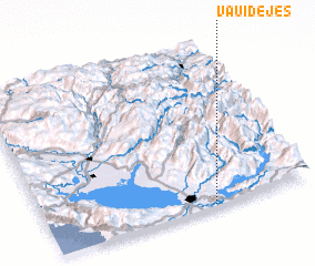 Places with similar names to Vau i Dejës, Albania ::
Disclaimer :: Information on this page comes without warranty of any kind |
||
|
Where is Vau i Dejës? Elevation and coordinates ::
Latitude (lat): 42°0'36"N Longitude (lon): 19°37'29"E
Elevation (approx.): 30m (map arrows pan, magnifying glasses zoom) |
||
|
Visiting Vau i Dejës? Hotel/Accommodation ::
Book a hotel in Vau i Dejës Travel Guide ::
Buy a travel guide for Albania rental cars ::
car rental offers GPS waypoint ::
download a GPX waypoint (PoI) of Vau i Dejës for your GPS receiver
|
||