|
search place name
|
||
Vojnikë (Dibër, Albania)Vojnikë is a town in the Dibër region of Albania. An overview map of the region around Vojnikë is displayed below.
regional and 3d topo map of Vojnikë, Albania ::

Vojnikë airports ::
The nearest airport is OHD - Ohrid, located 50.5 km south east of Vojnikë.
Other airports nearby include TIA - Tirana Rinas (64.1 km west), SKP - Skopje (105.7 km north east), PRN - Pristina (120.2 km north east), TGD - Podgorica (132.1 km north west), Nearby towns ::
Burim (0.6km south east) //
Çernenë (1.1km north east) //
Podgorcë (1.5km south) //
Fusha e Vogël (1.6km north) //
Kovashicë (2.1km north) //
Majtarë (1.9km south east) //
Bllata e Poshtëme (2.7km south east) //
Maqellarë (2.4km east) //
Gradec (3.1km north) //
Pesjakë (2.8km north east) //
Gjorica e Poshtme (3.6km south) //
Okshatinë (3.0km south west) //
Topojan (2.9km west) //
Grazhdan (3.8km north east) //
Bllata e Epërme (3.4km south east) //
Spas (4.0km south east) //
Dovolan (4.6km north) //
Herebel (4.5km north) //
Mitrović (4.2km south east) //
Gjorica e Sipërme (5.2km south) //
Pocest (4.0km east) //
Taraneš (5.0km south) //
Popinarë (4.8km north east) //
Erebarë (5.4km north) //
Šulan (5.0km south east) //
Homesh (4.7km south west) //
Kërçishti i Poshtëm (4.2km east) //
Boçevë (5.1km south west) //
Katundi i Vogël (4.5km north east) //
[all distances 'as the bird flies' and approximate] 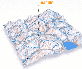 Places with similar names to Vojnikë, Albania ::
Disclaimer :: Information on this page comes without warranty of any kind |
||
|
Where is Vojnikë? Elevation and coordinates ::
Latitude (lat): 41°34'50"N Longitude (lon): 20°27'22"E
Elevation (approx.): 519m (map arrows pan, magnifying glasses zoom) |
||
|
Visiting Vojnikë? Hotel/Accommodation ::
Book a hotel in Vojnikë Travel Guide ::
Buy a travel guide for Albania rental cars ::
car rental offers GPS waypoint ::
download a GPX waypoint (PoI) of Vojnikë for your GPS receiver
|
||