|
search place name
|
||
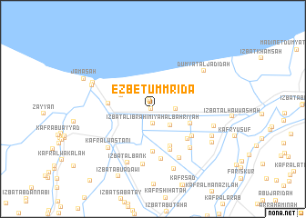
`Ezbet Umm Riḍa (Dumyāţ, Egypt)`Ezbet Umm Riḍa is a town in the Dumyāţ region of Egypt. An overview map of the region around `Ezbet Umm Riḍa is displayed below.
regional and 3d topo map of `Ezbet Umm Riḍa, Egypt ::
`Ezbet Umm Riḍa airports ::
The nearest airport is PSD - Port Said, located 60.9 km east of `Ezbet Umm Riḍa.
Other airports nearby include CAI - Cairo Intl (144.0 km south), ALY - Alexandria Intl (160.9 km west), Nearby towns ::
‘Izbat Sālim ‘Uthmān (0.2km west) //
‘Izbat Umm Riḑā al Jadīdah (1.2km north) //
‘Izbat al Ibrāhīmīyah al Baḩrīyah (1.8km south) //
Naj‘ al Jabāylah (2.3km east) //
Al ‘Abbāsīyah (2.7km south east) //
Ar Rikābīyah al Jadīdah (3.7km north west) //
As Sa‘īdīyah al Baḩrīyah (4.3km south east) //
Al Muhandisīn (4.9km south) //
Al Muḩammadīyah (5.2km south) //
Ar Rikābīyah (4.7km west) //
Al Fuʼādīyah (5.4km south) //
Ad Dinjūh (5.2km south east) //
As Sa‘īdīyah al Qiblīyah (5.3km south east) //
‘Izbat Şiddīq Shiḩātah (6.2km south) //
Al Ḩusānīyah (6.2km south east) //
Ḩayy al ‘Urūbah (6.6km south east) //
‘Izbat al Alfī (6.9km south) //
Kafr al Wasţānī (6.6km south west) //
‘Izbat al Bank (7.1km south) //
An Nāşirīyah (7.7km south) //
‘Izbat at Tawfīqīyah Raqm Ithnayn (6.8km east) //
Dumyāţ al Jadīdah (7.1km north east) //
‘Izbat al Ismā‘īlīyah Raqm Thalāthah (7.0km south east) //
‘Izbat Jamaşah ash Sharqīyah (7.0km north west) //
‘Izbat Jamaşah al Gharbīyah (7.1km north west) //
‘Izbat al Ismā‘īlīyah Raqm Arba‘ah (7.4km south east) //
Jamaşah (8.2km north west) //
‘Izbat Abū ‘Adawī (9.1km south west) //
‘Izbat Abū Sa‘ādah al Kubrá (11.0km south west) //
[all distances 'as the bird flies' and approximate]  Places with similar names to `Ezbet Umm Riḍa, Egypt :: Disclaimer :: Information on this page comes without warranty of any kind |
||
|
Where is `Ezbet Umm Riḍa? Elevation and coordinates ::
Latitude (lat): 31°24'29"N Longitude (lon): 31°37'6"E
Elevation (approx.): 2m (map arrows pan, magnifying glasses zoom) |
||
|
Visiting `Ezbet Umm Riḍa? Hotel/Accommodation ::
Book a hotel in `Ezbet Umm Riḍa Travel Guide ::
Buy a travel guide for Egypt rental cars ::
car rental offers GPS waypoint ::
download a GPX waypoint (PoI) of `Ezbet Umm Riḍa for your GPS receiver
|
||