|
search place name
|
||
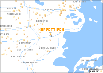
Kafr at Tir‘ah (Ash Sharqīyah, Egypt)Kafr at Tir‘ah is a town in the Ash Sharqīyah region of Egypt. An overview map of the region around Kafr at Tir‘ah is displayed below.
regional and 3d topo map of Kafr at Tir‘ah, Egypt ::
Kafr at Tir‘ah airports ::
The nearest airport is PSD - Port Said, located 36.3 km north east of Kafr at Tir‘ah.
Other airports nearby include CAI - Cairo Intl (117.8 km south west), ALY - Alexandria Intl (190.1 km west), Nearby towns ::
Difrīyah (1.5km south) //
‘Izbat aţ Ţawīl (3.1km north east) //
‘Izbat Abū al Akhḑar (3.9km north west) //
‘Izbat al Mutawallī ‘Alī (4.0km west) //
‘Izbat al ‘Ajāyzah (5.4km south) //
Al Biţānīyah (5.3km north west) //
‘Izbat Muḩammad al Barād‘ī al Qiblīyah (5.6km south) //
‘Izbat aţ Ţūbijīyah (6.4km north west) //
‘Izbat Ḩasan Abū ‘Abduh (6.5km north east) //
‘Izbat ‘Alī Zakī (6.7km north west) //
Al Furūsāt (7.6km north) //
Al ‘Āmirah (7.6km north west) //
Judayyidat al Manzilah (8.1km north) //
‘Izbat al Jayyār (7.9km north east) //
‘Izbat al Bayḑāʼ (7.9km south west) //
‘Izbat aţ Ţāhirī (7.9km north west) //
Awlād Ḩānah (8.3km north) //
‘Izbat al ‘Abbāsīyah (7.8km north west) //
Al Manzilah (8.8km north) //
‘Izbat as Sayyid ‘Imārah (7.7km west) //
As Satāʼitah (8.7km north west) //
Al ‘Amārinah (9.1km north) //
‘Izbat al Hanāydah (9.1km north) //
‘Izbat al Başāylah (9.2km north) //
‘Izbat ar Rawḑah (9.0km north west) //
Kafr Ḩajjāj (9.6km north west) //
Mīt Khuḑayr (9.7km north west) //
‘Izbat al Gharābiwah (9.3km north west) //
[all distances 'as the bird flies' and approximate]  Places with similar names to Kafr at Tir‘ah, Egypt ::
// Kafr ad Dawwār (EG)
// Kafr ad Dawwār (EG)
// Kafr ad Dayr (EG)
// Kafr ad Dayr (EG)
// Kafr aḑ Ḑurrah (JO)
// Kafr ad Dawwār (EG)
// Kvartir (HR)
Disclaimer :: Information on this page comes without warranty of any kind |
||
|
Where is Kafr at Tir‘ah? Elevation and coordinates ::
Latitude (lat): 31°4'45"N Longitude (lon): 31°56'20"E
Elevation (approx.): 1m (map arrows pan, magnifying glasses zoom) |
||
|
Visiting Kafr at Tir‘ah? Hotel/Accommodation ::
Book a hotel in Kafr at Tir‘ah Travel Guide ::
Buy a travel guide for Egypt rental cars ::
car rental offers GPS waypoint ::
download a GPX waypoint (PoI) of Kafr at Tir‘ah for your GPS receiver
|
||