|
search place name
|
||
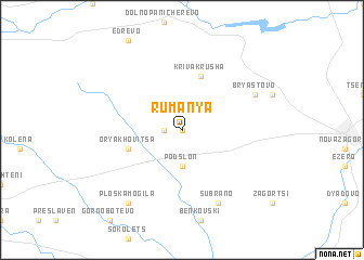
Rumanya (Bulgaria)Rumanya is a town in Bulgaria. An overview map of the region around Rumanya is displayed below.
regional and 3d topo map of Rumanya, Bulgaria ::
Rumanya airports ::
The nearest airport is GOZ - Gorna Orechovica Gorna Oryahovitsa, located 73.5 km north of Rumanya.
Other airports nearby include PDV - Plovdiv (96.6 km south west), BOJ - Bourgas Burgas (135.7 km east), VAR - Varna (179.5 km north east), AXD - Alexandroupolis Dimokritos (182.8 km south), Nearby towns ::
Bratya Kunchevi (0.0km north) //
Cherkovo (1.4km west) //
Podslon (3.7km south) //
Kriva Krusha (5.7km north) //
Oryakhovitsa (4.5km south west) //
Bryastovo (6.6km north east) //
Sŭbrano (7.9km south) //
Ploska Mogila (8.5km south west) //
[all distances 'as the bird flies' and approximate]  Places with similar names to Rumanya, Bulgaria ::
// Rumah Nyua (MY)
// Romonya (HU)
// Raḩmānīyah (IQ)
// Raḩmānīyah (SD)
// Raḩmānīyeh (IR)
// Raḩmānīyeh (IR)
// Raḩmānīyeh (IR)
// Rahmānīyeh (IR)
// Raḩmānīyah (SY)
// Remen'ye (RU)
Disclaimer :: Information on this page comes without warranty of any kind |
||
|
Where is Rumanya? Elevation and coordinates ::
Latitude (lat): 42°30'0"N Longitude (lon): 25°52'0"E
Elevation (approx.): 215m (map arrows pan, magnifying glasses zoom) |
||
|
Visiting Rumanya? Hotel/Accommodation ::
Book a hotel in Rumanya Travel Guide ::
Buy a travel guide for Bulgaria rental cars ::
car rental offers GPS waypoint ::
download a GPX waypoint (PoI) of Rumanya for your GPS receiver
|
||