|
search place name
|
||
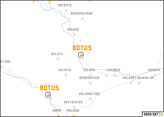
Botuş (Covurlui, Romania)Botuş is a town in the Covurlui region of Romania. An overview map of the region around Botuş is displayed below.
regional and 3d topo map of Botuş, Romania ::
Botuş airports ::
The nearest airport is SCV - Suceava Stefan Cel Mare, located 76.7 km east of Botuş.
Other airports nearby include TGM - Tirgu Mures Vidrasau (141.4 km south west), BAY - Baia Mare Tautii Magheraus (141.7 km west), CLJ - Cluj-napoca Cluj Napoca (153.2 km south west), BCM - Bacau (166.0 km south east), Nearby towns ::
Vîrfu Plaiului (0.0km north) //
Botuşel (0.0km north) //
Braniştea (0.0km north) //
Colacu (0.0km north) //
Lefe (0.0km north) //
Obcina (0.0km north) //
Pîrîu Floarei (0.0km north) //
Pîrîu Negrii (0.0km north) //
Plai (0.0km north) //
Smida Ungurenilor (0.0km north) //
Colacu (3.9km south) //
Delniţa (4.5km south west) //
Deluţu (3.8km west) //
Arseneasca (5.7km south) //
Breaza (5.7km north) //
Măgura (5.7km north) //
Fundu Moldovei (5.3km south east) //
Răchitiş (6.2km south east) //
Tătarca (6.2km south east) //
[all distances 'as the bird flies' and approximate]  Places with similar names to Botuş, Romania ::
Disclaimer :: Information on this page comes without warranty of any kind |
||
|
Where is Botuş? Elevation and coordinates ::
Latitude (lat): 47°34'0"N Longitude (lon): 25°21'0"E
Elevation (approx.): 991m (map arrows pan, magnifying glasses zoom) |
||
|
Visiting Botuş? Hotel/Accommodation ::
Book a hotel in Botuş Travel Guide ::
Buy a travel guide for Romania rental cars ::
car rental offers GPS waypoint ::
download a GPX waypoint (PoI) of Botuş for your GPS receiver
|
||