|
search place name
|
||
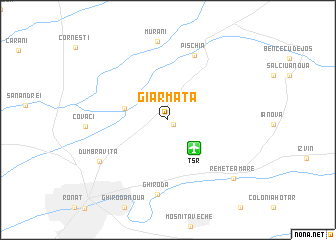
Giarmata (Timiş, Romania)Giarmata is a town in the Timiş region of Romania. An overview map of the region around Giarmata is displayed below.
regional and 3d topo map of Giarmata, Romania ::
Giarmata airports ::
The nearest airport is TSR - Timisoara Traian Vuia, located 3.8 km south east of Giarmata.
Other airports nearby include ARW - Arad (37.8 km north), CSB - Caransebes (87.0 km south east), BEG - Beograd (137.9 km south west), OMR - Oradea (139.6 km north), Nearby towns ::
Giarmata Vii (0.7km south east) //
Cerneteaz (3.7km west) //
Pişchia (7.5km north) //
Ghiroda (8.3km south) //
Murani (8.8km north) //
Dumbrăviţa (7.0km south west) //
Remetea Mare (8.3km south east) //
[all distances 'as the bird flies' and approximate]  Places with similar names to Giarmata, Romania ::
// Germete (DE)
// Germade (ES)
// Germeade (ES)
// Jarmet (ET)
// Jaramito (VE)
// Jirmātī (SY)
// Jauro Amadu (NG)
// Jauro Amadu (NG)
// Jaramatáia (BR)
// Jaramtai (CN)
Disclaimer :: Information on this page comes without warranty of any kind |
||
|
Where is Giarmata? Elevation and coordinates ::
Latitude (lat): 45°50'18"N Longitude (lon): 21°18'39"E
Elevation (approx.): 110m (map arrows pan, magnifying glasses zoom) |
||
|
Visiting Giarmata? Hotel/Accommodation ::
Book a hotel in Giarmata Travel Guide ::
Buy a travel guide for Romania rental cars ::
car rental offers GPS waypoint ::
download a GPX waypoint (PoI) of Giarmata for your GPS receiver
|
||