|
search place name
|
||
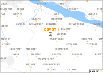
Pasatu (Ukraine)Pasatu is a town in Ukraine. An overview map of the region around Pasatu is displayed below.
regional and 3d topo map of Pasatu, Ukraine ::
Pasatu airports ::
The nearest airport is SCV - Suceava Stefan Cel Mare, located 57.0 km south of Pasatu.
Other airports nearby include IAS - Iasi (159.4 km south east), BCM - Bacau (193.2 km south), TGM - Tirgu Mures Vidrasau (227.2 km south west), Nearby towns ::
Sloboda (1.9km north) //
Velikaya-Buda (2.2km south east) //
Lukovitsa (3.7km north) //
Buda-Mike (2.5km east) //
Godineshti (4.1km north east) //
Mamornitsa (5.7km north) //
Kotul Bainskiy (5.2km north west) //
Magosheshti (6.1km south east) //
Zurin (7.5km north) //
Migoreni (7.5km south) //
Molodiya (6.7km north west) //
Becheshti (6.2km south east) //
Tarashany (7.4km south west) //
Fundoaya (7.4km south east) //
Prevoroki (8.3km south west) //
[all distances 'as the bird flies' and approximate] 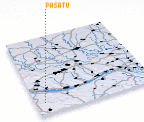 Places with similar names to Pasatu, Ukraine ::
Disclaimer :: Information on this page comes without warranty of any kind |
||
|
Where is Pasatu? Elevation and coordinates ::
Latitude (lat): 48°10'0"N Longitude (lon): 26°5'0"E
Elevation (approx.): 189m (map arrows pan, magnifying glasses zoom) |
||
|
Visiting Pasatu? Hotel/Accommodation ::
Book a hotel in Pasatu Travel Guide ::
Buy a travel guide for Ukraine rental cars ::
car rental offers GPS waypoint ::
download a GPX waypoint (PoI) of Pasatu for your GPS receiver
|
||