|
search place name
|
||
Castrotierra (Castilla y León, Spain)Castrotierra is a town in the Castilla y León region of Spain. An overview map of the region around Castrotierra is displayed below.
regional and 3d topo map of Castrotierra, Spain ::

Castrotierra airports ::
The nearest airport is VLL - Valladolid, located 78.8 km south east of Castrotierra.
Other airports nearby include BGC - Braganca (132.3 km south west), OVD - Aviles Asturias (149.2 km north west), SLM - Salamanca (156.7 km south), SDR - Santander (167.2 km north east), Nearby towns ::
La Veguellina (2.3km south west) //
Castrovega de Valmadrigal (4.6km south west) //
Vallecillo (4.1km east) //
Villeza (4.5km south east) //
Matallana de Valmadrigal (4.5km south west) //
Santa Cristina de Valmadrigal (4.5km north west) //
Grañeras (6.2km north east) //
Villamoratiel de las Matas (6.9km north west) //
Valverde-Enrique (6.9km south west) //
El Burgo Ranero (7.9km north) //
San Miguel de Montañán (7.8km south east) //
[all distances 'as the bird flies' and approximate] 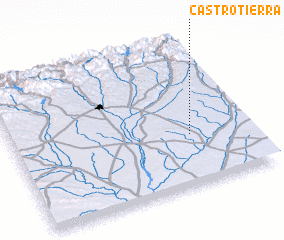 Places with similar names to Castrotierra, Spain ::
// Castro Daire (PT)
// Castro de Oro (ES)
// Castro de Rey (ES)
// Kūz Tārtara (PK)
// Castro de Rey (ES)
Disclaimer :: Information on this page comes without warranty of any kind |
||
|
Where is Castrotierra? Elevation and coordinates ::
Latitude (lat): 42°21'0"N Longitude (lon): 5°15'0"W
Elevation (approx.): 825m (map arrows pan, magnifying glasses zoom) |
||
|
Visiting Castrotierra? Hotel/Accommodation ::
Book a hotel in Castrotierra Travel Guide ::
Buy a travel guide for Spain rental cars ::
car rental offers GPS waypoint ::
download a GPX waypoint (PoI) of Castrotierra for your GPS receiver
|
||