|
search place name
|
||
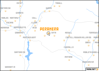
Peramera (Cataluña, Spain)Peramera is a town in the Cataluña region of Spain. An overview map of the region around Peramera is displayed below.
regional and 3d topo map of Peramera, Spain ::
Peramera airports ::
The nearest airport is LEU - Seo De Urgel, located 49.6 km east of Peramera.
Other airports nearby include LDE - Tarbes Lourdes (108.2 km north west), LRH - La Rochelle Lherm (120.3 km north), TLS - Toulouse Blagnac (141.9 km north), REU - Reus (144.0 km south), Nearby towns ::
Erta (1.4km east) //
Erill-Castell (1.4km west) //
Irgo (4.5km north west) //
Benés (4.5km south east) //
Llesp (5.5km north west) //
Sarahís (6.2km north west) //
Irán (6.2km north west) //
Mesull (5.5km east) //
Pont de Suert (5.8km west) //
Coll (6.9km north west) //
Cherallo (7.8km south east) //
[all distances 'as the bird flies' and approximate] 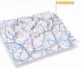 Places with similar names to Peramera, Spain ::
// Primor (BR)
// Primor (BR)
// Parramore (US)
// Praia a Mare (IT)
// Péra Meriá (GR)
// Parameira (PT)
// Pîrîu Mare (RO)
// Pîrîu Morii (RO)
// Pirömer (TR)
// Prámaro (ES)
Disclaimer :: Information on this page comes without warranty of any kind |
||
|
Where is Peramera? Elevation and coordinates ::
Latitude (lat): 42°25'0"N Longitude (lon): 0°49'0"W
Elevation (approx.): 1382m (map arrows pan, magnifying glasses zoom) |
||
|
Visiting Peramera? Hotel/Accommodation ::
Book a hotel in Peramera Travel Guide ::
Buy a travel guide for Spain rental cars ::
car rental offers GPS waypoint ::
download a GPX waypoint (PoI) of Peramera for your GPS receiver
|
||