|
search place name
|
||
Puendeluna (Aragón, Spain)Puendeluna is a town in the Aragón region of Spain. An overview map of the region around Puendeluna is displayed below.
regional and 3d topo map of Puendeluna, Spain ::

Puendeluna airports ::
The nearest airport is ZAZ - Zaragoza Ab, located 58.9 km south west of Puendeluna.
Other airports nearby include PNA - Pamplona (100.9 km north west), LDE - Tarbes Lourdes (129.5 km north east), PUF - Pau Pyrenees (139.3 km north), EAS - San Sebastian (158.8 km north west), Nearby towns ::
Puipullín (2.3km south east) //
Presa del Gállego (3.7km north) //
Casas de Esper (4.5km north west) //
Sierra de los Blancos (5.7km north) //
Piedratajada (5.5km south west) //
Marracos (7.9km south) //
[all distances 'as the bird flies' and approximate] 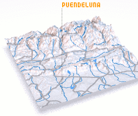 Places with similar names to Puendeluna, Spain ::
// Pentolina (IT)
// Panaitólion (GR)
// Pantaleón (CU)
// Puntallana (ES)
// Puente Llano (CO)
// Punta El Llano (GT)
// Pantoloan (ID)
// Pendalian (ID)
// Pantaleón (MX)
// Punta Allen (MX)
Disclaimer :: Information on this page comes without warranty of any kind |
||
|
Where is Puendeluna? Elevation and coordinates ::
Latitude (lat): 42°9'0"N Longitude (lon): 0°45'0"W
Elevation (approx.): 404m (map arrows pan, magnifying glasses zoom) |
||
|
Visiting Puendeluna? Hotel/Accommodation ::
Book a hotel in Puendeluna Travel Guide ::
Buy a travel guide for Spain rental cars ::
car rental offers GPS waypoint ::
download a GPX waypoint (PoI) of Puendeluna for your GPS receiver
|
||