|
search place name
|
||
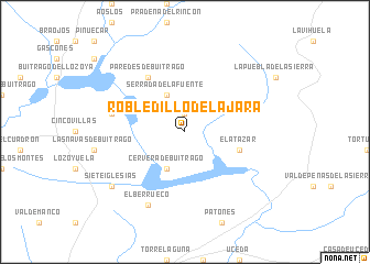
Robledillo de la Jara (Madrid, Spain)Robledillo de la Jara is a town in the Madrid region of Spain. An overview map of the region around Robledillo de la Jara is displayed below.
regional and 3d topo map of Robledillo de la Jara, Spain ::
Robledillo de la Jara airports ::
The nearest airport is TOJ - Madrid Torrejon, located 50.7 km south of Robledillo de la Jara.
Other airports nearby include MAD - Madrid Barajas (50.9 km south), VLL - Valladolid (139.8 km north west), SLM - Salamanca (167.2 km west), VIT - Vitoria (224.5 km north), Nearby towns ::
Berzosa del Lozoya (1.9km north) //
Serrada de la Fuente (4.0km north) //
Cervera de Buitrago (4.0km south) //
El Atazar (4.6km south east) //
Paredes de Buitrago (6.2km north west) //
Manjirón (5.9km west) //
El Berrueco (7.9km south) //
Sieteiglesias (7.9km south west) //
[all distances 'as the bird flies' and approximate] 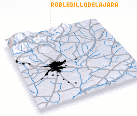 Places with similar names to Robledillo de la Jara, Spain :: Disclaimer :: Information on this page comes without warranty of any kind |
||
|
Where is Robledillo de la Jara? Elevation and coordinates ::
Latitude (lat): 40°57'0"N Longitude (lon): 3°31'0"W
Elevation (approx.): 1092m (map arrows pan, magnifying glasses zoom) |
||
|
Visiting Robledillo de la Jara? Hotel/Accommodation ::
Book a hotel in Robledillo de la Jara Travel Guide ::
Buy a travel guide for Spain rental cars ::
car rental offers GPS waypoint ::
download a GPX waypoint (PoI) of Robledillo de la Jara for your GPS receiver
|
||