|
search place name
|
||
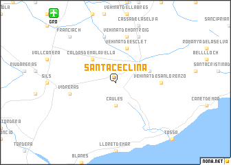
Santa Ceclina (Cataluña, Spain)Santa Ceclina is a town in the Cataluña region of Spain. An overview map of the region around Santa Ceclina is displayed below.
regional and 3d topo map of Santa Ceclina, Spain ::
Santa Ceclina airports ::
The nearest airport is GRO - Gerona Girona, located 13.5 km north west of Santa Ceclina.
Other airports nearby include BCN - Barcelona (85.2 km south west), PGF - Perpignan Rivesaltes (104.5 km north), LEU - Seo De Urgel (133.4 km north west), REU - Reus (158.1 km south west), Nearby towns ::
Caulés (3.7km south) //
Caldas de Malavella (4.6km north west) //
Llagostera (4.5km north east) //
Vehinat de Esclet (5.7km north) //
Vehinat de San Lorenzo (5.5km east) //
Vidreras (5.8km west) //
Vehinat de Montroig (7.5km north) //
San Andrés Salou (7.5km north) //
Seriñá (7.9km north) //
Franciach (9.2km north west) //
[all distances 'as the bird flies' and approximate] 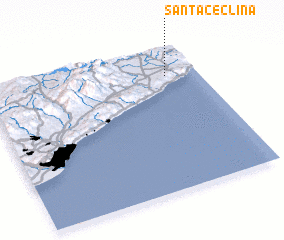 Places with similar names to Santa Ceclina, Spain ::
// Sainte-Sigolène (FR)
// Saint-Séglin (FR)
Disclaimer :: Information on this page comes without warranty of any kind |
||
|
Where is Santa Ceclina? Elevation and coordinates ::
Latitude (lat): 41°48'0"N Longitude (lon): 2°51'0"E
Elevation (approx.): 178m (map arrows pan, magnifying glasses zoom) |
||
|
Visiting Santa Ceclina? Hotel/Accommodation ::
Book a hotel in Santa Ceclina Travel Guide ::
Buy a travel guide for Spain rental cars ::
car rental offers GPS waypoint ::
download a GPX waypoint (PoI) of Santa Ceclina for your GPS receiver
|
||