|
search place name
|
||
Villarrube (Galicia, Spain)Villarrube is a town in the Galicia region of Spain. An overview map of the region around Villarrube is displayed below.
regional and 3d topo map of Villarrube, Spain ::

Villarrube airports ::
The nearest airport is LCG - La Coruna A Coruna, located 44.6 km south west of Villarrube.
Other airports nearby include SCQ - Santiago (86.6 km south), VGO - Vigo (162.3 km south), BGC - Braganca (226.5 km south east), Nearby towns ::
Cedeira (2.3km north east) //
Pantín (2.7km west) //
Esteiro (2.7km east) //
Loira (3.3km south west) //
Vilaboa (3.9km south) //
Piñeiro (4.6km north east) //
Régoa (6.2km north east) //
Cerdido (5.7km east) //
Montojo (5.7km east) //
Monte (7.9km south) //
Valdoviño (6.5km south west) //
Bardaos (7.9km south) //
Cerbo (7.9km north) //
Abad (7.7km south east) //
[all distances 'as the bird flies' and approximate] 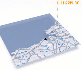 Places with similar names to Villarrube, Spain ::
// Vallorbe (CH)
// Vale Arriba (PT)
// Villarraba (ES)
// Villarrabé (ES)
// Villarriba (ES)
// Villarrubia (ES)
// Villarrubio (ES)
// Villorobe (ES)
// Villoruebo (ES)
// Villa Ruby (CO)
Disclaimer :: Information on this page comes without warranty of any kind |
||
|
Where is Villarrube? Elevation and coordinates ::
Latitude (lat): 43°38'0"N Longitude (lon): 8°4'0"W
Elevation (approx.): 91m (map arrows pan, magnifying glasses zoom) |
||
|
Visiting Villarrube? Hotel/Accommodation ::
Book a hotel in Villarrube Travel Guide ::
Buy a travel guide for Spain rental cars ::
car rental offers GPS waypoint ::
download a GPX waypoint (PoI) of Villarrube for your GPS receiver
|
||