|
search place name
|
||
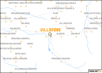
Villorobe (Castilla y León, Spain)Villorobe is a town in the Castilla y León region of Spain. An overview map of the region around Villorobe is displayed below.
regional and 3d topo map of Villorobe, Spain ::
Villorobe airports ::
The nearest airport is VIT - Vitoria, located 81.8 km north east of Villorobe.
Other airports nearby include BIO - Bilbao (116.5 km north), SDR - Santander (131.4 km north), VLL - Valladolid (142.1 km south west), PNA - Pamplona (148.1 km east), Nearby towns ::
Herramel (0.0km north) //
Uzquiza (1.4km west) //
Alarcia (2.7km east) //
Haedillo (5.7km north) //
Villasur de Herreros (4.5km north west) //
Villamudria (5.5km north east) //
Rábanos (5.8km east) //
Alba (7.5km north) //
Urrez (6.6km south west) //
[all distances 'as the bird flies' and approximate] 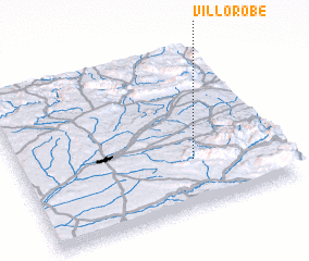 Places with similar names to Villorobe, Spain ::
// Vallorbe (CH)
// Vale Arriba (PT)
// Villarraba (ES)
// Villarrabé (ES)
// Villarriba (ES)
// Villarrube (ES)
// Villarrubia (ES)
// Villarrubio (ES)
// Villoruebo (ES)
// Villa Ruby (CO)
Disclaimer :: Information on this page comes without warranty of any kind |
||
|
Where is Villorobe? Elevation and coordinates ::
Latitude (lat): 42°18'0"N Longitude (lon): 3°20'0"W
Elevation (approx.): 1083m (map arrows pan, magnifying glasses zoom) |
||
|
Visiting Villorobe? Hotel/Accommodation ::
Book a hotel in Villorobe Travel Guide ::
Buy a travel guide for Spain rental cars ::
car rental offers GPS waypoint ::
download a GPX waypoint (PoI) of Villorobe for your GPS receiver
|
||