|
search place name
|
||
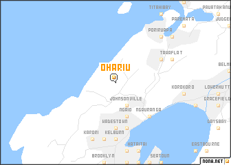
Ohariu (Akaroa, New Zealand)Ohariu is a town in the Akaroa region of New Zealand. An overview map of the region around Ohariu is displayed below.
regional and 3d topo map of Ohariu, New Zealand ::
Ohariu airports ::
The nearest airport is WLG - Wellington Intl, located 14.5 km south of Ohariu.
Other airports nearby include PPQ - Paraparaumu (37.8 km north east), MRO - Masterton (77.1 km east), BHE - Woodbourne (82.9 km south west), PMR - Palmerston North (121.2 km north east), Nearby towns ::
Johnsonville (4.0km south) //
Ngaio (5.7km south) //
Khandallah (5.7km south) //
Wadestown (7.4km south) //
Kaiwharawhara (7.5km south) //
Ngauranga (7.0km south east) //
Linden (6.7km north east) //
Porirua Pa (9.3km north east) //
[all distances 'as the bird flies' and approximate] 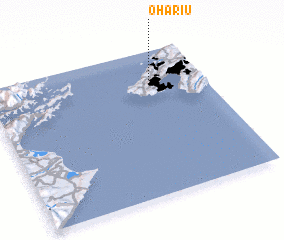 Places with similar names to Ohariu, New Zealand ::
Disclaimer :: Information on this page comes without warranty of any kind |
||
|
Where is Ohariu? Elevation and coordinates ::
Latitude (lat): 41°12'0"S Longitude (lon): 174°46'0"E
Elevation (approx.): 191m (map arrows pan, magnifying glasses zoom) |
||
|
Visiting Ohariu? Hotel/Accommodation ::
Book a hotel in Ohariu Travel Guide ::
Buy a travel guide for New Zealand rental cars ::
car rental offers GPS waypoint ::
download a GPX waypoint (PoI) of Ohariu for your GPS receiver
|
||