|
search place name
|
||
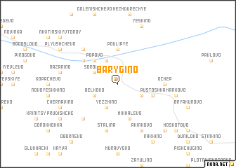
Barygino (Novgorodskaya Oblast', Russia)Barygino is a town in the Novgorodskaya Oblast' region of Russia. An overview map of the region around Barygino is displayed below.
regional and 3d topo map of Barygino, Russia ::
Barygino airports ::
The nearest airport is KLD - Tver Migalovo, located 211.1 km south of Barygino.
Nearby towns ::
Ostrov (2.1km north east) //
Sorokino (2.7km north west) //
Bel'kovo (2.7km south west) //
Gora (2.7km south west) //
Gorbukhino (2.7km south east) //
Klimovshchino (3.8km north) //
Yezzhino (3.8km south) //
Popovo (4.2km north west) //
Podlip'ye (5.6km north) //
Mikhalëvo (5.6km south) //
Pustoshka (3.4km south east) //
Tokarëvo (4.7km north west) //
Ochep (3.8km east) //
Stalina (7.5km south) //
Tychkino (6.3km south west) //
Opalëvo (6.3km north west) //
Akin'kovo (7.7km south) //
Dunevka (8.4km south east) //
[all distances 'as the bird flies' and approximate] 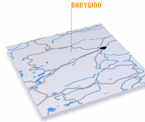 Places with similar names to Barygino, Russia ::
// Bergen (AT)
// Bergen (AT)
// Bergin (AT)
// Brögen (AT)
// Burro John (US)
// Bargen (DE)
// Bargen (DE)
// Bargen (DE)
// Bargen (DE)
// Bauerrögen (DE)
Disclaimer :: Information on this page comes without warranty of any kind |
||
|
Where is Barygino? Elevation and coordinates ::
Latitude (lat): 58°43'0"N Longitude (lon): 35°33'0"E
Elevation (approx.): 144m (map arrows pan, magnifying glasses zoom) |
||
|
Visiting Barygino? Hotel/Accommodation ::
Book a hotel in Barygino Travel Guide ::
Buy a travel guide for Russia rental cars ::
car rental offers GPS waypoint ::
download a GPX waypoint (PoI) of Barygino for your GPS receiver
|
||