|
search place name
|
||
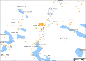
Veli (Tverskaya Oblast', Russia)Veli is a town in the Tverskaya Oblast' region of Russia. An overview map of the region around Veli is displayed below.
regional and 3d topo map of Veli, Russia ::
Veli airports ::
The nearest airport is KLD - Tver Migalovo, located 130.3 km south east of Veli.
Nearby towns ::
Martus (0.6km north) //
Lyadiny (0.5km west) //
Salpa (1.6km south) //
Dubrovo (1.6km north) //
Serebryaniki (2.4km south) //
Podol (2.1km south west) //
Staroye-Kotchishche (3.1km south) //
Lipovets (1.9km north west) //
Alekseyevskoye (2.5km north east) //
Sadovyy (3.9km south) //
Novoye-Kotchishche (4.0km south) //
Dunay (3.8km north east) //
Garusovo (4.7km north) //
Malyy-Gorodok (4.8km south) //
Lutkovo (4.9km north) //
Bol'shoy-Gorodok (5.8km south) //
Norfino (4.4km north east) //
Girino (6.7km north) //
Pochep (6.5km north) //
Valentinovka (6.2km south) //
Zhelnikha (7.3km south) //
Radunka (6.3km south west) //
Staroye Pochvino (8.9km south) //
Manuylovo (6.0km north east) //
Perevoz (8.7km north) //
Novoye Pochvino (8.7km south) //
Tubosskaya Gorka (8.3km north west) //
[all distances 'as the bird flies' and approximate]  Places with similar names to Veli, Russia ::
Disclaimer :: Information on this page comes without warranty of any kind |
||
|
Where is Veli? Elevation and coordinates ::
Latitude (lat): 57°46'27"N Longitude (lon): 34°29'40"E
Elevation (approx.): 162m (map arrows pan, magnifying glasses zoom) |
||
|
Visiting Veli? Hotel/Accommodation ::
Book a hotel in Veli Travel Guide ::
Buy a travel guide for Russia rental cars ::
car rental offers GPS waypoint ::
download a GPX waypoint (PoI) of Veli for your GPS receiver
|
||