|
search place name
|
||
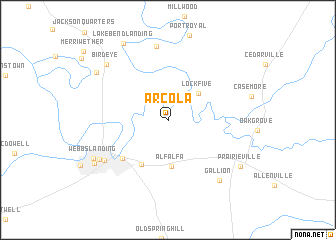
Arcola (Alabama, United States - USA)Arcola is a town in the Alabama region of United States - USA. An overview map of the region around Arcola is displayed below.
regional and 3d topo map of Arcola, United States - USA ::
Arcola airports ::
The nearest airport is NMM - Meridian Nas, located 74.0 km west of Arcola.
Other airports nearby include MXF - Montgomery Maxwell Afb (133.2 km east), CBM - Colombus Columbus Afb (136.1 km north west), BHM - Birmingham Intl (146.3 km north east), MOB - Mobile Rgnl (211.7 km south), Nearby towns ::
Lock Five (4.1km north east) //
Alfalfa (5.2km south) //
Knoxwood (5.5km south west) //
Spocari (6.1km south west) //
Gilmore Quarters (8.3km north) //
Baptist Hill (7.5km south west) //
Gallion (8.3km south east) //
Demopolis (7.8km south west) //
Birdeye (8.5km north west) //
Webbs Landing (8.2km south west) //
Rockcut (8.5km south west) //
Roe Landing (8.6km north west) //
Prairieville (8.6km south east) //
Lake Bend Landing (9.5km north west) //
[all distances 'as the bird flies' and approximate] 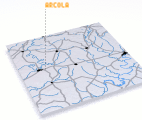 Places with similar names to Arcola, United States - USA ::
Disclaimer :: Information on this page comes without warranty of any kind |
||
|
Where is Arcola? Elevation and coordinates ::
Latitude (lat): 32°33'25"N Longitude (lon): 87°46'3"W
Elevation (approx.): 41m (map arrows pan, magnifying glasses zoom) |
||
|
Visiting Arcola? Hotel/Accommodation ::
Book a hotel in Arcola Travel Guide ::
rental cars ::
car rental offers GPS waypoint ::
download a GPX waypoint (PoI) of Arcola for your GPS receiver
|
||