|
search place name
|
||
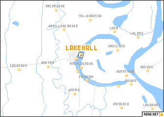
Lakehall (Arkansas, United States - USA)Lakehall is a town in the Arkansas region of United States - USA. An overview map of the region around Lakehall is displayed below.
regional and 3d topo map of Lakehall, United States - USA ::
Lakehall airports ::
The nearest airport is GWO - Greenwood Leflore, located 111.8 km east of Lakehall.
Other airports nearby include MLU - Monroe Rgnl (115.6 km south west), ELD - El Dorado South Arkansas Rgnl At Goodwin Fld (144.2 km west), JAN - Jackson Evers Intl (158.9 km south east), LIT - Little Rock Adams Fld (178.6 km north west), Nearby towns ::
Lake Village (1.0km west) //
Myrtle Grove (2.0km south) //
Chanticleer (3.2km south) //
Fairview (5.1km south) //
McMillan Corner (7.4km north west) //
Ashton (6.6km west) //
Jennie (8.2km south) //
Vaucluse (7.0km east) //
Yellow Bayou (9.0km north) //
Luna (8.6km north east) //
Red Leaf (9.3km south east) //
[all distances 'as the bird flies' and approximate]  Places with similar names to Lakehall, United States - USA ::
// Laukhella (NO)
// Lake Hill (US)
// Lackey Hill (US)
// Luke Hill (BB)
// Lāukhola (BD)
// Lukhalo (ZM)
// Lakhāla (PK)
// Likhoele (LS)
// Lucky Hill (JM)
// Lake Hallie (US)
Disclaimer :: Information on this page comes without warranty of any kind |
||
|
Where is Lakehall? Elevation and coordinates ::
Latitude (lat): 33°19'42"N Longitude (lon): 91°16'14"W
Elevation (approx.): 40m (map arrows pan, magnifying glasses zoom) |
||
|
Visiting Lakehall? Hotel/Accommodation ::
Book a hotel in Lakehall Travel Guide ::
rental cars ::
car rental offers GPS waypoint ::
download a GPX waypoint (PoI) of Lakehall for your GPS receiver
|
||