|
search place name
|
||
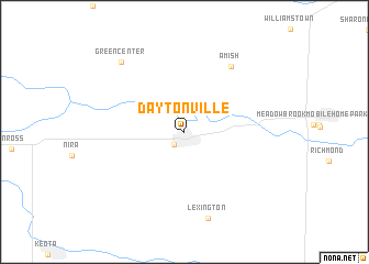
Daytonville (Iowa, United States - USA)Daytonville is a town in the Iowa region of United States - USA. An overview map of the region around Daytonville is displayed below.
regional and 3d topo map of Daytonville, United States - USA ::
Daytonville airports ::
The nearest airport is DSM - Des Moines Intl, located 153.3 km west of Daytonville.
Nearby towns ::
Wellman (1.5km south west) //
Amish (7.5km north east) //
Lexington (8.9km south) //
Green Center (8.6km north west) //
[all distances 'as the bird flies' and approximate]  Places with similar names to Daytonville, United States - USA ::
// Teiu din Vale (RO)
// Dudenville (US)
// Duttonville (US)
// Daytonville (US)
// Tottenville (US)
// Deatonville (US)
// Dadonville (FR)
// Totainville (FR)
// Toutainville (FR)
// Diadéinoufla (CI)
Disclaimer :: Information on this page comes without warranty of any kind |
||
|
Where is Daytonville? Elevation and coordinates ::
Latitude (lat): 41°28'34"N Longitude (lon): 91°49'44"W
Elevation (approx.): 242m (map arrows pan, magnifying glasses zoom) |
||
|
Visiting Daytonville? Hotel/Accommodation ::
Book a hotel in Daytonville Travel Guide ::
rental cars ::
car rental offers GPS waypoint ::
download a GPX waypoint (PoI) of Daytonville for your GPS receiver
|
||