|
search place name
|
||
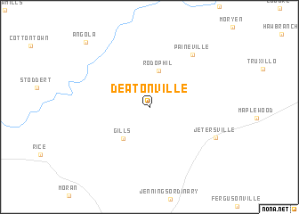
Deatonville (Virginia, United States - USA)Deatonville is a town in the Virginia region of United States - USA. An overview map of the region around Deatonville is displayed below.
regional and 3d topo map of Deatonville, United States - USA ::
Deatonville airports ::
The nearest airport is RIC - Richmond Intl, located 77.7 km east of Deatonville.
Other airports nearby include PHF - Newport News Williamsburg Intl (150.3 km east), LFI - Hampton Langley Afb (162.8 km east), RDU - Raleigh-durham Raleigh Durham Intl (170.2 km south), NGU - Norfolk Ns (172.5 km east), Nearby towns ::
Rodophil (4.6km north) //
Gills (4.7km south west) //
Paineville (7.8km north east) //
Jetersville (7.6km south east) //
Angola (10.3km north west) //
[all distances 'as the bird flies' and approximate]  Places with similar names to Deatonville, United States - USA ::
// Daytonville (US)
// Teiu din Vale (RO)
// Dudenville (US)
// Duttonville (US)
// Daytonville (US)
// Tottenville (US)
// Dadonville (FR)
// Totainville (FR)
// Toutainville (FR)
// Diadéinoufla (CI)
Disclaimer :: Information on this page comes without warranty of any kind |
||
|
Where is Deatonville? Elevation and coordinates ::
Latitude (lat): 37°19'41"N Longitude (lon): 78°10'7"W
Elevation (approx.): 136m (map arrows pan, magnifying glasses zoom) |
||
|
Visiting Deatonville? Hotel/Accommodation ::
Book a hotel in Deatonville Travel Guide ::
rental cars ::
car rental offers GPS waypoint ::
download a GPX waypoint (PoI) of Deatonville for your GPS receiver
|
||