|
search place name
|
||
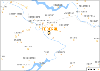
Federal (Kentucky, United States - USA)Federal is a town in the Kentucky region of United States - USA. An overview map of the region around Federal is displayed below.
regional and 3d topo map of Federal, United States - USA ::
Federal airports ::
The nearest airport is HKY - Hickory Rgnl, located 194.8 km south east of Federal.
Other airports nearby include TYS - Knoxville Mc Ghee Tyson (221.6 km south west), Nearby towns ::
Beaver Bottom (0.4km north) //
Dunleary (0.9km north west) //
Elkhorn City (1.2km south east) //
Belcher (3.5km north) //
Cedarville (3.3km north east) //
Honey Fork (4.0km north) //
Draffin (4.5km north west) //
Road Junction (5.2km north west) //
Mikegrady (5.3km north east) //
Republic (6.8km north) //
Tivis (7.3km south) //
Ratliff (6.7km north west) //
Dry Fork (6.6km west) //
Bartlick (7.9km south east) //
Wolfpit (7.2km north west) //
Marrowbone (7.6km north west) //
Venters (7.1km west) //
Breaks (7.3km east) //
Ashcamp (8.3km south west) //
Lick Creek (9.5km north east) //
[all distances 'as the bird flies' and approximate] 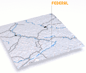 Places with similar names to Federal, United States - USA ::
Disclaimer :: Information on this page comes without warranty of any kind |
||
|
Where is Federal? Elevation and coordinates ::
Latitude (lat): 37°18'41"N Longitude (lon): 82°21'40"W
Elevation (approx.): 267m (map arrows pan, magnifying glasses zoom) |
||
|
Visiting Federal? Hotel/Accommodation ::
Book a hotel in Federal Travel Guide ::
rental cars ::
car rental offers GPS waypoint ::
download a GPX waypoint (PoI) of Federal for your GPS receiver
|
||