|
search place name
|
||
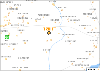
Truitt (Maryland, United States - USA)Truitt is a town in the Maryland region of United States - USA. An overview map of the region around Truitt is displayed below.
regional and 3d topo map of Truitt, United States - USA ::
Truitt airports ::
The nearest airport is SBY - Salisbury Ocean City Wicomico Rgnl, located 12.7 km west of Truitt.
Other airports nearby include WWD - Wildwood Cape May Co (83.6 km north east), DOV - Dover Afb (87.3 km north), NHK - Patuxent River Nas (91.7 km west), MIV - Millville Muni (116.2 km north), Nearby towns ::
Berlin West (1.6km south) //
Powellville (2.2km south west) //
Mount Pleasant (2.8km east) //
Willards (5.2km north) //
New Hope (5.6km north east) //
Whiton (6.4km south) //
Timmonstown (5.4km east) //
Poplar Neck (7.1km north) //
Pittsville (6.8km north west) //
Libertytown (6.6km south east) //
Whaleyville (7.8km north east) //
Duncan Crossing (8.2km north east) //
Glass Hill (8.0km north west) //
[all distances 'as the bird flies' and approximate]  Places with similar names to Truitt, United States - USA ::
Disclaimer :: Information on this page comes without warranty of any kind |
||
|
Where is Truitt? Elevation and coordinates ::
Latitude (lat): 38°20'48"N Longitude (lon): 75°21'56"W
Elevation (approx.): 9m (map arrows pan, magnifying glasses zoom) |
||
|
Visiting Truitt? Hotel/Accommodation ::
Book a hotel in Truitt Travel Guide ::
rental cars ::
car rental offers GPS waypoint ::
download a GPX waypoint (PoI) of Truitt for your GPS receiver
|
||