|
search place name
|
||
Ironia (New Jersey, United States - USA)Ironia is a town in the New Jersey region of United States - USA. An overview map of the region around Ironia is displayed below.
regional and 3d topo map of Ironia, United States - USA ::

Ironia airports ::
The nearest airport is EWR - Newark Liberty Intl, located 41.2 km east of Ironia.
Other airports nearby include TEB - Teterboro (47.8 km east), TTN - Trenton Mercer (62.7 km south), LGA - New York La Guardia (63.8 km east), JFK - New York John F Kennedy Intl (74.4 km east), Nearby towns ::
Coleman Hollow (1.9km south east) //
Succasunna (5.2km north) //
Ralston (5.7km south) //
Mendham (5.6km south) //
Mount Freedom (4.7km east) //
Kenvil (6.4km north) //
Carey (5.7km north west) //
Mine Hill (6.7km north east) //
Mount Fern (6.2km north east) //
Brookside (5.8km south east) //
Ledgewood (7.0km north) //
Pleasant Hill (6.0km west) //
Flanders (6.3km north west) //
Pleasant Valley (8.3km south) //
Sutton Park (6.7km west) //
Mill Brook (7.4km north east) //
Chester (7.4km south west) //
Wharton (8.6km north east) //
Washington Corner (8.1km south east) //
Shippenport (9.2km north west) //
Dover (8.6km north east) //
[all distances 'as the bird flies' and approximate] 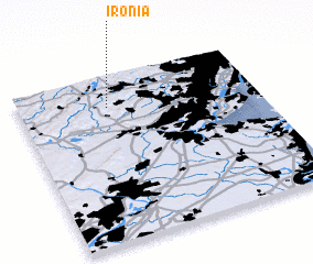 Places with similar names to Ironia, United States - USA ::
Disclaimer :: Information on this page comes without warranty of any kind |
||
|
Where is Ironia? Elevation and coordinates ::
Latitude (lat): 40°49'22"N Longitude (lon): 74°37'34"W
Elevation (approx.): 275m (map arrows pan, magnifying glasses zoom) |
||
|
Visiting Ironia? Hotel/Accommodation ::
Book a hotel in Ironia Travel Guide ::
rental cars ::
car rental offers GPS waypoint ::
download a GPX waypoint (PoI) of Ironia for your GPS receiver
|
||