|
search place name
|
||
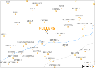
Fullers (Virginia, United States - USA)Fullers is a town in the Virginia region of United States - USA. An overview map of the region around Fullers is displayed below.
regional and 3d topo map of Fullers, United States - USA ::
Fullers airports ::
The nearest airport is HKY - Hickory Rgnl, located 153.4 km south east of Fullers.
Other airports nearby include INT - Winston-salem Smith Reynolds (193.6 km south east), TYS - Knoxville Mc Ghee Tyson (215.0 km south west), CLT - Charlotte Douglas Intl (223.7 km south east), Nearby towns ::
Nash Ford (3.9km south east) //
Artrip (4.2km south west) //
Rasnake (4.7km north) //
Coulwood (4.1km east) //
Pondtown (7.9km south) //
Jahile (6.9km north west) //
Cleveland (7.7km south west) //
Purcell (8.2km south west) //
Corner (7.5km south east) //
Flatwoods (7.1km north east) //
South Clinchfield (7.9km south west) //
Fuller Corner (8.3km north east) //
[all distances 'as the bird flies' and approximate] 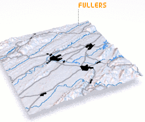 Places with similar names to Fullers, United States - USA ::
Disclaimer :: Information on this page comes without warranty of any kind |
||
|
Where is Fullers? Elevation and coordinates ::
Latitude (lat): 36°59'55"N Longitude (lon): 82°6'0"W
Elevation (approx.): 499m (map arrows pan, magnifying glasses zoom) |
||
|
Visiting Fullers? Hotel/Accommodation ::
Book a hotel in Fullers Travel Guide ::
rental cars ::
car rental offers GPS waypoint ::
download a GPX waypoint (PoI) of Fullers for your GPS receiver
|
||