|
search place name
|
||
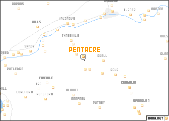
Pentacre (West Virginia, United States - USA)Pentacre is a town in the West Virginia region of United States - USA. An overview map of the region around Pentacre is displayed below.
regional and 3d topo map of Pentacre, United States - USA ::
Pentacre airports ::
The nearest airport is EKN - Elkins Randolph Co Jennings Randolph, located 145.6 km north east of Pentacre.
Other airports nearby include LCK - Columbus Rickenbacker Intl (205.8 km north west), CMH - Port Columbus Intl (220.0 km north west), Nearby towns ::
Quick (2.0km south) //
Coco (2.0km north west) //
Coalridge (2.2km south east) //
Schrader (3.2km north west) //
Odell (3.3km east) //
Victor (4.2km north west) //
Sanderson (4.2km south east) //
Three Mile (5.0km north west) //
Acup (6.2km south east) //
Blount (8.0km south) //
Youngs Bottom (8.2km north) //
Falling Rock (8.7km north) //
Pinch (7.1km west) //
Blue Creek (8.2km north west) //
Walgrove (8.7km north) //
Cinco (8.1km south west) //
Fivemile (8.2km south west) //
Elkview (8.9km north west) //
Rensford (10.9km south west) //
[all distances 'as the bird flies' and approximate]  Places with similar names to Pentacre, United States - USA ::
// Ponta Curuá (BR)
// Ponto Carro (PT)
// Puente Agüero (ES)
// Pondokeurih (ID)
// Pandácuareo (MX)
// Pendakaré (SN)
// Pandogari (NG)
// Pantikare (NG)
// Panti Kura (NG)
// Pontcarré (FR)
Disclaimer :: Information on this page comes without warranty of any kind |
||
|
Where is Pentacre? Elevation and coordinates ::
Latitude (lat): 38°23'25"N Longitude (lon): 81°24'13"W
Elevation (approx.): 220m (map arrows pan, magnifying glasses zoom) |
||
|
Visiting Pentacre? Hotel/Accommodation ::
Book a hotel in Pentacre Travel Guide ::
rental cars ::
car rental offers GPS waypoint ::
download a GPX waypoint (PoI) of Pentacre for your GPS receiver
|
||