|
search place name
|
||
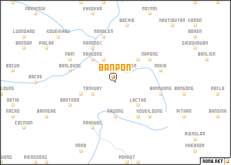
Bản Pon (Cao Bằng, Vietnam)Bản Pon is a town in the Cao Bằng region of Vietnam. An overview map of the region around Bản Pon is displayed below.
regional and 3d topo map of Bản Pon, Vietnam ::
Bản Pon airports ::
The nearest airport is HAN - Hanoi Noibai Intl, located 170.7 km south of Bản Pon.
Nearby towns ::
Phia Hien (2.5km north east) //
Tan Kuay (3.9km south west) //
Bo Vat (4.1km north west) //
Na Vuong (5.0km north west) //
Bản Ngoc (5.0km south east) //
Lạc Thổ (5.0km south east) //
Na Heo (5.0km north east) //
Na Ðông (5.6km south) //
Bản Tan (2) (5.5km west) //
Làng Ca Phu (6.5km north west) //
Na Pong (2) (6.5km north west) //
Ná Pong (6.3km north east) //
Bang Veng (6.5km south east) //
Bản Loung (7.1km west) //
Na Ma Len (7.6km north) //
Bản Muông (7.1km east) //
Na Kié (7.1km east) //
Kouei Loung (7.6km south east) //
Khan Phac (8.2km south west) //
Nam Duoc (8.2km south west) //
Bản Tran (7.8km south west) //
Na Ri (7.8km north west) //
[all distances 'as the bird flies' and approximate] 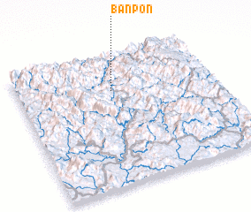 Places with similar names to Bản Pon, Vietnam ::
// Binapon (PH)
// Ban Na Pan (TH)
// Ban Na Pan (TH)
// Ban Na Po Nua (TH)
// Ban Na Pun (TH)
// Ban Na Pun (TH)
// Ban Paen (TH)
// Ban Paen (TH)
// Ban Paen (TH)
// Ban Pan (TH)
Disclaimer :: Information on this page comes without warranty of any kind |
||
|
Where is Bản Pon? Elevation and coordinates ::
Latitude (lat): 22°44'0"N Longitude (lon): 105°29'0"E
Elevation (approx.): 373m (map arrows pan, magnifying glasses zoom) |
||
|
Visiting Bản Pon? Hotel/Accommodation ::
Book a hotel in Bản Pon Travel Guide ::
Buy a travel guide for Vietnam rental cars ::
car rental offers GPS waypoint ::
download a GPX waypoint (PoI) of Bản Pon for your GPS receiver
|
||