|
search place name
|
||
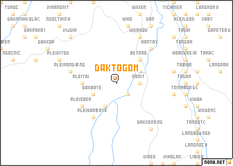
Daktogom (Vietnam)Daktogom is a town in Vietnam. An overview map of the region around Daktogom is displayed below.
regional and 3d topo map of Daktogom, Vietnam ::
Daktogom airports ::
The nearest airport is DAD - Danang Intl, located 132.7 km north of Daktogom.
Nearby towns ::
Man Dit (2.6km south east) //
Monit (3.6km east) //
Dak Baye (4.0km south west) //
Dak Jonn (4.0km north east) //
Nouk Bier (4.1km south west) //
Betrao (5.2km north east) //
Plei Yai (5.4km west) //
Plei Dar Baye (6.6km south west) //
Plei Soen (6.5km south west) //
Plei Man Diang (7.4km west) //
Plei Djak (7.4km west) //
Mantay (7.7km north east) //
Wikamou (8.2km north east) //
Dak Xe Rong (9.2km south east) //
Plei Breo (10.3km north west) //
Vi Juih (10.3km north west) //
[all distances 'as the bird flies' and approximate] 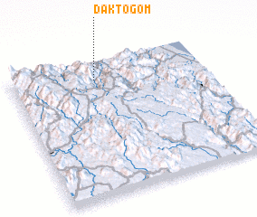 Places with similar names to Daktogom, Vietnam ::
// Dugda Kʼumbī (ET)
Disclaimer :: Information on this page comes without warranty of any kind |
||
|
Where is Daktogom? Elevation and coordinates ::
Latitude (lat): 14°52'0"N Longitude (lon): 108°26'0"E
Elevation (approx.): 406m (map arrows pan, magnifying glasses zoom) |
||
|
Visiting Daktogom? Hotel/Accommodation ::
Book a hotel in Daktogom Travel Guide ::
Buy a travel guide for Vietnam rental cars ::
car rental offers GPS waypoint ::
download a GPX waypoint (PoI) of Daktogom for your GPS receiver
|
||