|
search place name
|
||
Quế Dương (Vietnam)Quế Dương is a town in Vietnam. An overview map of the region around Quế Dương is displayed below.
regional and 3d topo map of Quế Dương, Vietnam ::

Quế Dương airports ::
The nearest airport is HAN - Hanoi Noibai Intl, located 23.9 km north east of Quế Dương.
Nearby towns ::
Dương Liễu (1.7km east) //
Yên Sở (1.7km east) //
Cát Ngòi (1.7km west) //
Mậu Hòa (1.9km north) //
Ðắc Sở (1.9km south) //
Thọ Láo (1.9km south) //
Tiền Lệ (2.5km south east) //
Phúc Ðức (2.5km south west) //
Khánh Tàn (3.7km south) //
Sơn Ðồng (3.5km east) //
Thâp Thuan (4.1km north west) //
Ða Phúc (4.1km south west) //
Hòa Thôn (3.9km north west) //
Ðan Phượng (4.4km north) //
Ðan Hội (5.1km north east) //
Chung Thuy (5.1km north east) //
Phương Viên (5.1km south east) //
Thuan Nhue (5.1km north west) //
Phùng Thôn (5.1km south west) //
Hạ Hiệp (5.2km west) //
Dị Nậu (5.2km west) //
Cổ Ngõa (5.6km north) //
Tiền Lê Trai (5.6km south) //
Ðại Tự (5.2km east) //
Hoàng Xá (5.8km south) //
Bình Xá (5.5km west) //
Lưu Xá (5.5km east) //
Thuong Thon (5.5km east) //
Ðại Diền (6.4km north west) //
[all distances 'as the bird flies' and approximate] 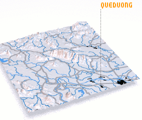 Places with similar names to Quế Dương, Vietnam ::
Disclaimer :: Information on this page comes without warranty of any kind |
||
|
Where is Quế Dương? Elevation and coordinates ::
Latitude (lat): 21°3'0"N Longitude (lon): 105°40'0"E
Elevation (approx.): 12m (map arrows pan, magnifying glasses zoom) |
||
|
Visiting Quế Dương? Hotel/Accommodation ::
Book a hotel in Quế Dương Travel Guide ::
Buy a travel guide for Vietnam rental cars ::
car rental offers GPS waypoint ::
download a GPX waypoint (PoI) of Quế Dương for your GPS receiver
|
||