|
search place name
|
||
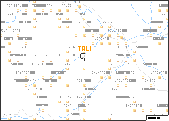
Ta Li (Vietnam)Ta Li is a town in Vietnam. An overview map of the region around Ta Li is displayed below.
regional and 3d topo map of Ta Li, Vietnam ::
Ta Li airports ::
The nearest airport is HAN - Hanoi Noibai Intl, located 242.0 km south east of Ta Li.
Nearby towns ::
Quang Kim (1.9km north) //
Súng Mong (1.9km south) //
Tòng Xành (1.9km south) //
Loung Giang (2.5km north west) //
Bac Van (2.5km north east) //
Tchong Ho (3.4km west) //
Lao Toang (3.4km west) //
Sung Bang (3.9km north west) //
Côc My (4.1km north east) //
Làng Kim (4.1km north east) //
Ly Ta (3.9km south west) //
Lo Sui Tong (3.9km south west) //
Muong Xan (5.0km north east) //
Chu Kang Hồ (5.0km south east) //
Ma Tinh (5.6km north) //
Bản Lang (5.6km north) //
Coc Xan (5.1km east) //
Dồng Tuyền (5.1km east) //
Pò Sì Ngai (5.6km south) //
Bản Kiang Sui Tao (5.8km north) //
Cốc San (5.5km east) //
Bàn Kiang (5.8km north) //
Nhat Son (5.8km north) //
Cum Hạ (6.3km north east) //
Trung Chải (6.5km south west) //
Bản Quang (6.5km north east) //
Sin Tchay (6.3km south west) //
Lão Van Tchay (6.3km south east) //
Làng Nang (7.4km north) //
[all distances 'as the bird flies' and approximate]  Places with similar names to Ta Li, Vietnam ::
Disclaimer :: Information on this page comes without warranty of any kind |
||
|
Where is Ta Li? Elevation and coordinates ::
Latitude (lat): 22°28'0"N Longitude (lon): 103°53'0"E
Elevation (approx.): 534m (map arrows pan, magnifying glasses zoom) |
||
|
Visiting Ta Li? Hotel/Accommodation ::
Book a hotel in Ta Li Travel Guide ::
Buy a travel guide for Vietnam rental cars ::
car rental offers GPS waypoint ::
download a GPX waypoint (PoI) of Ta Li for your GPS receiver
|
||