|
search place name
|
||
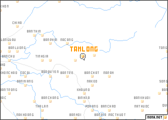
Tam Lộng (Lạng Sơn, Vietnam)Tam Lộng is a town in the Lạng Sơn region of Vietnam. An overview map of the region around Tam Lộng is displayed below.
regional and 3d topo map of Tam Lộng, Vietnam ::
Tam Lộng airports ::
The nearest airport is NNG - Nanning Wuxu, located 142.0 km north east of Tam Lộng.
Other airports nearby include HAN - Hanoi Noibai Intl (151.0 km south west), Nearby towns ::
Mac Pẻng (1.7km west) //
Banlan (2.4km north east) //
Bản Chắt (4.1km south east) //
Na Cang (5.1km north west) //
Bản Tre (5.1km south west) //
Na Keo (5.8km south) //
Na Râm (6.4km south east) //
Khảu Nô (7.4km south) //
Nà Dua (6.9km west) //
Bản Quyền (7.8km south west) //
Bản Phải (7.8km north west) //
[all distances 'as the bird flies' and approximate] 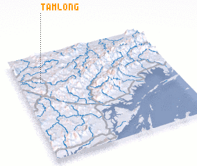 Places with similar names to Tam Lộng, Vietnam ::
Disclaimer :: Information on this page comes without warranty of any kind |
||
|
Where is Tam Lộng? Elevation and coordinates ::
Latitude (lat): 21°45'0"N Longitude (lon): 107°9'0"E
Elevation (approx.): 432m (map arrows pan, magnifying glasses zoom) |
||
|
Visiting Tam Lộng? Hotel/Accommodation ::
Book a hotel in Tam Lộng Travel Guide ::
Buy a travel guide for Vietnam rental cars ::
car rental offers GPS waypoint ::
download a GPX waypoint (PoI) of Tam Lộng for your GPS receiver
|
||