|
search place name
|
||
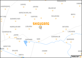
Shigugang (Zhejiang, China)Shigugang is a town in the Zhejiang region of China. An overview map of the region around Shigugang is displayed below.
regional and 3d topo map of Shigugang, China ::
Shigugang airports ::
The nearest airport is HGH - Hangzhou Xiaoshan, located 108.9 km south east of Shigugang.
Other airports nearby include NKG - Nanjing Lukou (116.3 km north west), SHA - Shanghai Hongqiao Intl (162.0 km east), NGB - Ninbo Lishe (213.1 km south east), Nearby towns ::
Changzhong (5.1km north) //
Yunfeng (5.2km north west) //
Luojiadi (4.7km west) //
Si'an (5.9km south) //
Xianshan (7.6km south west) //
Shijiekou (7.5km north east) //
Guandaijie (7.6km south east) //
Dongchuanling (8.8km north west) //
Bojiacun (9.7km north east) //
[all distances 'as the bird flies' and approximate] 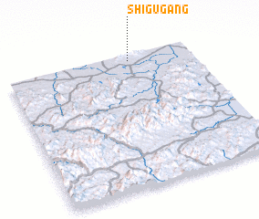 Places with similar names to Shigugang, China ::
// Shakagonga (CD)
// Chak Gangu (IN)
// Chack Gang (PK)
// Ch'i-kuei-k'eng (TW)
// Hsiao-kuei-k'eng (TW)
// T'iao-ku-k'eng (TW)
// Chagugang (CN)
Disclaimer :: Information on this page comes without warranty of any kind |
||
|
Where is Shigugang? Elevation and coordinates ::
Latitude (lat): 30°57'1"N Longitude (lon): 119°39'48"E
Elevation (approx.): 65m (map arrows pan, magnifying glasses zoom) |
||
|
Visiting Shigugang? Hotel/Accommodation ::
Book a hotel in Shigugang Travel Guide ::
Buy a travel guide for China rental cars ::
car rental offers GPS waypoint ::
download a GPX waypoint (PoI) of Shigugang for your GPS receiver
|
||