|
search place name
|
||
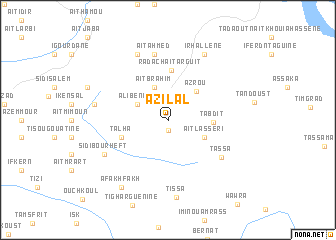
Azilal (Azilal, Morocco)Azilal is a town in the Azilal region of Morocco. An overview map of the region around Azilal is displayed below.
regional and 3d topo map of Azilal, Morocco ::
Azilal airports ::
The nearest airport is OZZ - Ouarzazate, located 118.5 km south of Azilal.
Other airports nearby include RAK - Marrakech Menara (144.5 km west), CMN - Casablanca Mohammed V Intl (182.4 km north west), MEK - Meknes Bassatine (233.9 km north east), FEZ - Fez Saiss (263.5 km north east), Nearby towns ::
Sidi Abdallah (1.1km south) //
Ali Ben Ali (3.4km north west) //
Aït Brahim (3.9km north) //
Aït Lasseri (3.9km south east) //
Azrou (4.1km north east) //
Ta‘bdit (4.2km east) //
Radach Aït Arguit (5.5km north) //
Talha (4.8km south west) //
Tassa (6.5km south east) //
Aït Ahmed (7.5km north) //
Sidi Bourheft (7.1km south west) //
Aït Sidi Lahsene (7.9km north) //
Ifrane (7.2km west) //
Irhallene (8.1km north east) //
Tissa (8.6km south) //
Afakhfakh (8.7km south west) //
[all distances 'as the bird flies' and approximate]  Places with similar names to Azilal, Morocco ::
// Azulillo (MX)
// As Silayyil (SA)
// As Sulayyil (SA)
// Az̧ Z̧ilāl (SA)
// Aslyyaly (RU)
// Az̧ Z̧alīl (LB)
// As Salālah (YE)
// As Salīl (YE)
// As Salīl (YE)
// As Salīl (YE)
Disclaimer :: Information on this page comes without warranty of any kind |
||
|
Where is Azilal? Elevation and coordinates ::
Latitude (lat): 31°58'1"N Longitude (lon): 6°34'10"W
Elevation (approx.): 1373m (map arrows pan, magnifying glasses zoom) |
||
|
Visiting Azilal? Hotel/Accommodation ::
Book a hotel in Azilal Travel Guide ::
Buy a travel guide for Morocco rental cars ::
car rental offers GPS waypoint ::
download a GPX waypoint (PoI) of Azilal for your GPS receiver
|
||